Solomonovo
| Solomonovo | ||
| Соломоново | ||

|
|
|
| Basic data | ||
|---|---|---|
| Oblast : | Zakarpattia Oblast | |
| Rajon : | Uzhhorod Raion | |
| Height : | 105 m | |
| Area : | 6.15 km² | |
| Residents : | 1,387 (2004) | |
| Population density : | 226 inhabitants per km² | |
| Postcodes : | 89460 | |
| Area code : | +380 312 | |
| Geographic location : | 48 ° 26 ' N , 22 ° 10' E | |
| KOATUU : | 2124886201 | |
| Administrative structure : | 1 village | |
| Mayor : | Halyna Malynych | |
| Address: | вул. Миру 2 89460 с. Соломоново |
|
| Statistical information | ||
|
|
||
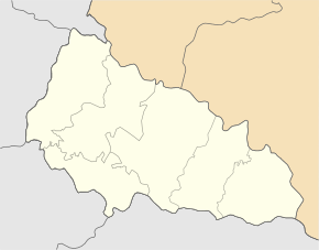
Solomonowo (Ukrainian and Russian Соломоново ; Slovak Salamúnová , Hungarian Tiszasalamon ) is a place in Uzhhorod Raion in the Zakarpattia Oblast in western Ukraine on the border with Slovakia .
The place is the westernmost inhabited point of Ukraine. From here to the easternmost village Rannja Zorya it is about 1500 km. In 1332 Solomonowo was first mentioned as Salmon and has about 1300 inhabitants. The border with Slovakia runs west of the local area.
Until 1919 the place belonged to the Empire Austria-Hungary or Hungary , afterwards as part of the Carpathian-Ukraine to Czechoslovakia . With the annexation of the Carpathian Ukraine, Hungary was reunited in 1938–1945; from 1945 the place has been part of the Soviet Union and since 1991 part of the Ukraine.
To the north-east of the town center there is a plant belonging to the Škoda auto supplier Eurocar .


