
Somogyudvarhely
| Somogyudvarhely | |||||
|
|||||
| Basic data | |||||
|---|---|---|---|---|---|
| State : | Hungary | ||||
| Region : | Southern Transdanubia | ||||
| County : | Somogy | ||||
| Small area until December 31, 2012 : | Csurgó | ||||
| District since 1.1.2013 : | Csurgó | ||||
| Coordinates : | 46 ° 11 ' N , 17 ° 11' E | ||||
| Area : | 40.42 km² | ||||
| Residents : | 1,066 (Jan. 1, 2011) | ||||
| Population density : | 26 inhabitants per km² | ||||
| Telephone code : | (+36) 82 | ||||
| Postal code : | 7515 | ||||
| KSH kódja: | 04853 | ||||
| Structure and administration (as of 2020) | |||||
| Community type : | local community | ||||
| Mayor : | Kornél Kiss (Fidesz-KDNP) | ||||
| Postal address : | Jókai Mór u. 2 7515 Somogyudvarhely |
||||
| Website : | |||||
| (Source: A Magyar Köztársaság helységnévkönyve 2011. január 1st at Központi statisztikai hivatal ) | |||||


Somogyudvarhely ( Croatian Dvorišće ) is a Hungarian community in the county Csurgó in Somogy county .
Geographical location
Somogyudvarhely is not far from the border with Croatia . Neighboring communities are Berzence and Bélavár . On the other side of the Croatian border is the place Ždala .
Community partnerships
Attractions
- Quarry ponds ( Bányatavak )
- Reformed Church, built in 1856
- Roman Catholic Church Szűz Mária neve , built in the last quarter of the 19th century
- Szeklertor ( Székelykapu )
- World War Memorial ( I-II. Világháborús emlék )
traffic
Road No. 6801 runs through Somogyudvarhely. The municipality is connected to the railway line from Pécs to Gyékényes .
photos
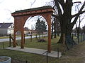
Szeklertor

Quarry pond


Individual evidence
- ↑ Öt Èvre kaptak bizalmat a somogyi polgármesterek. sonline.hu, October 14, 2019, accessed on February 26, 2020 (Hungarian).