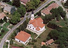
Gyékényes
| Gyékényes | ||||
|
||||
| Basic data | ||||
|---|---|---|---|---|
| State : | Hungary | |||
| Region : | Southern Transdanubia | |||
| County : | Somogy | |||
| Small area until December 31, 2012 : | Csurgó | |||
| District since 1.1.2013 : | Csurgó | |||
| Coordinates : | 46 ° 14 ' N , 17 ° 0' E | |||
| Area : | 33.76 km² | |||
| Residents : | 949 (Jan. 1, 2011) | |||
| Population density : | 28 inhabitants per km² | |||
| Telephone code : | (+36) 82 | |||
| Postal code : | 8851 | |||
| KSH kódja: | 30960 | |||
| Structure and administration (as of 2020) | ||||
| Community type : | local community | |||
| Mayoress : | Nikoletta Teszlákné Navracsics (independent) | |||
| Postal address : | Szabadság tér 7 8851 Gyékényes |
|||
| Website : | ||||
| (Source: A Magyar Köztársaság helységnévkönyve 2011. január 1st at Központi statisztikai hivatal ) | ||||
Gyékényes is a Hungarian community in the county Csurgó in Somogy county .
Geographical location
Gyékényes is located in the southwestern part of Hungary, a good seven kilometers southwest of the district town of Csurgó and about one kilometer from the border with Croatia . Neighboring communities are Porrogszentkirály and Zákány . The next larger city, Nagykanizsa, is 25 kilometers north. Beyond the border is the Croatian town of Gotalovo .
history
Gyékényes was first mentioned in a document around 1380. After the fall of Nagykanizsa in one of the Turkish Wars in 1600 , the village was conquered by the Turks. Only towards the end of the Second Turkish Siege of Vienna did the area come under Christian ownership again at the end of the 17th century. In 1859 a significant part of the village burned down. The settlements of Alsógyékényes and Felsőgyékényes , which were independent until then, united under the name Gyékényes, which gave rise to today's municipality. In 1870 the railway line from Gyékényes to Croatia was opened, and the first train from Gyékényes to Zagreb ran on January 5th of the same year. Since 1932 Kiestagebau has been operated on the edge of the settlement , which is an important employer for the local residents and the reason for the construction of the quarry pond.
nature
Gyékényes is characterized by a wooded area ( Lankóci erdő ). Since 1996 the place has been part of the Duna Dráva National Park . There are reed forest and chess flowers , and the forest stork nests in the municipality. In the village there is the Kotró, a nationally known quarry pond , which is part of a nature reserve. Furthermore, the area is characterized by vineyards.
Culture and sights
An important sight is the Roman Catholic Church Szent József, built in 1835 in the classicism style . The altarpiece was designed in 1886 by the Hungarian artist Károly Jakobey . The Protestant church was built in 1887 in neo-Gothic style according to the plans of Valentin Morandini. In addition, there is the torch monument ( Fáklyagyújtás-emlékmű ) and the wooden sculpture Anya gyemekével .
traffic
Gyékényes is a railway junction and one of the Hungarian border stations to and from Croatia. The railway lines (Budapest–) Székesfehérvár – Gyékényes , Dombóvár – Gyékényes , Gyékényes – Pécs and Gyékényes – Dugo Selo (–Zagreb) are linked together. Roads No. 6804 and No. 6808 meet in the village.
Web links
- Official website ( Hungarian )
- Gyékényes in A Pallas nagy lexikona (Hungarian)
Individual evidence
- ↑ Helyi önkormányzati választások 2019 - Gyékényes (Somogy megye). Nemzeti Választási Iroda, accessed February 4, 2020 (Hungarian).
- ↑ a b Gyékényes on gyekenyes-szallasajanlo.hu (accessed June 30, 2012)


