
Sonnensee (Hanover)
| Sun lake | ||
|---|---|---|
.jpg)
|
||
| Sonnensee (back left), Altwarmbüchener See (front right) | ||
| Geographical location | Hanover , Misburg district , Lower Saxony , Germany | |
| Data | ||
| Coordinates | 52 ° 24 '27 " N , 9 ° 52' 27" E | |
|
||
| Altitude above sea level | 58 m | |
| surface | 16 ha | |
| length | 720 m | |
| width | 200 m | |
| Maximum depth | 16 m | |

The Sonnensee is a quarry pond in Hanover in the Misburg district . It is part of the club's own sports and leisure facility.
The lake is located three kilometers northeast of the Mittelland Canal on the site of the Altwarmbüchener Moor . It stretches from northeast to southwest and has a length of 720 meters, its width is almost over the entire area 200 meters.
The district of Misburg is located two kilometers southwest of the lake and opens up the lake area via a paved road that crosses the east-west federal motorway 2 shortly before reaching the lake and continues into the densely wooded nature reserve of the Altwarmbüchener Moor.
To the northwest and north, the lake is surrounded by a 50 meter high ridge, which separates the lake area from the central landfill of Hanover, 500 meters away. The core of the ridge consists of landfill residues, but is covered by embankment material and is now forested; it is to be opened to the public as a recreational area in the near future.
At a distance of two kilometers from the Sonnensee, the federal motorway 37 runs from southwest to northeast , and federal motorway 7 from southeast to northwest , which crosses three kilometers north of the Sonnensee at the Hanover / Kirchhorst motorway junction .
The lake is surrounded by a narrow belt of reeds , which is, however, repeatedly interrupted by bathing areas; in the southern part there is also an extensive sandy beach and a sandy beach for small children. The area around the lake has been owned by the BffL (Association for Family Sports and Free Lifestyle) since 1947, which uses the entire area as a naturism campsite. There are hundreds of permanently installed caravans of the members on the total area, some meadow areas are also intended for guests.
The lake was created in 1962 during the construction of the Hanover-East motorway junction , when large amounts of gravel were needed to fill the junction , which the association made available from its 64 hectare grounds. What remained was a 16-hectare of ground water flowed through Stretch without direct inflow, which forms the centerpiece of the BffL theme parks.
photos
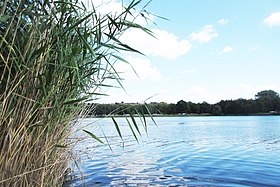
View from the shore of the lake

Club house with Sonnensee terrace


Web links
- Sonnensee on Hannover.de
- Sonnensee on the website of the BffL Sonnensee Hannover
- Larissa Holzki: People have been swimming naked at Sonnensee since 1962 . In: Hannoversche Allgemeine , September 2, 2012.
- Mark Bode: "A lighthouse worldwide" . In: Hallo Wochenblatt (Hanover), September 6, 2017.