
Soumarana
Location of Soumarana in Niger |

Soumarana is a village in the rural municipality of Safo in Niger .
The village, managed by a traditional chief ( chef traditionnel ), is located about 4.5 kilometers northwest of Safo, the capital of the rural community of the same name, which belongs to the Madarounfa department in the Maradi region of the same name . Like Riadi, Safo is part of a chain of southern suburbs of the city of Maradi . It lies on the banks of the periodically water-bearing Goulbin Maradi River . National Road 18 runs through the village between the city of Maradi and the state border with Nigeria .
Around 1820 Soumarana belonged to the Azna villages south of Maradi, which revolted against the rule of the Fulbe , which had been founded by Usman dan Fodio . The uprising favored the emergence of the independent state of Maradi under Dan Kassawa, who succeeded the Hausa state of Katsina . During the food crisis of 2005 Soumarana was one of the hardest hit places. The drinking water in the village came from a single contaminated well, which, especially in children , favored diseases caused by the guinea worm , cholera and diarrhea , until UNICEF had new water pumps and a reservoir built.
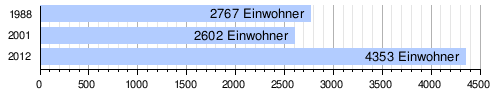
At the 2012 census, Soumarana had 4,353 inhabitants living in 616 households. At the 2001 census, the population was 2,602 in 387 households, and at the 1988 census, the population was 2,767 in 449 households.
The village is named after the Blanc de Soumarana ( "White from Soumarana"), which in addition to from Galmi originating Blanc de Galmi and Violet de Galmi the most famous onion - cultivars one from Niger.
Individual evidence
- ↑ a b National Repertoire des Localités (ReNaLoc). (RAR) Institut National de la Statistique de la République du Niger, July 2014, p. 268 , accessed on 7 August 2015 (French).
- ↑ Abdourahmane Idrissa, Samuel Decalo: Historical Dictionary of Niger . 4th edition. Scarecrow, Plymouth 2012, ISBN 978-0-8108-6094-0 , pp. 165-166 .
- ^ Sabine Dolan, Kun Li: Providing safe water for southern Niger. UNICEF, August 17, 2005, accessed October 27, 2018 .
- ^ Répertoire National des Communes (RENACOM). (RAR file) Institut National de la Statistique, accessed November 8, 2010 (French).
- ↑ Recensement Général de la Population 1988: Répertoire National des Villages du Niger . Bureau Central de Recensement, Ministère du Plan, République du Niger, Niamey March 1991, p. 132 ( ceped.org [PDF; accessed January 31, 2018]). www.ceped.org ( Memento of the original dated January 31, 2018 in the Internet Archive ) Info: The archive link was inserted automatically and has not yet been checked. Please check the original and archive link according to the instructions and then remove this notice.
- ^ Giorgia Robbiati, Abass Mallam Assoumane, Vieri Tarchiani: L'oignon du Niger. Étude d'une filière traditionnelle face à un marché globalisé . L'Harmattan, Paris 2012, ISBN 978-2-296-56282-0 , pp. 21-22 .
Coordinates: 13 ° 27 ' N , 7 ° 5' E