
Maradi (region)
| Maradi | |
|---|---|
  |
|
| Basic data | |
| Country | Niger |
| Capital | Maradi |
| surface | 41,796 km² |
| Residents | 3,402,094 (2012) |
| density | 81 inhabitants per km² |
| ISO 3166-2 | NE-4 |
| politics | |
| governor | Oumarou Zakari |
Coordinates: 13 ° 30 ' N , 7 ° 6' E
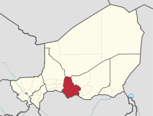
The Maradi region is one of the seven regions of Niger and is located in the south of the country. Their capital is Maradi . The region has 3,402,094 inhabitants (2012).
geography

Maradi borders the Tahoua region to the west, the Agadez region to the north, the Zinder region to the east and the Nigerian states of Katsina , Sokoto and Zamfara to the south . In geological terms, the region belongs to the Mesozoic era.
The Maradi region is divided into the eight departments of Aguié , Bermo , Dakoro , Gazaoua , Guidan Roumdji , Madarounfa , Mayahi and Tessaoua .
history
The Maradi region dates back to the French colonial era. In July 1922, Niger has been in nine circles (cercles) divided consisting of divisions (subdivisions) passed. Maradi County was made up of the subdivisions Maradi, Dakoro and Tessaoua. After Niger gained independence in 1960, the district was replaced on January 1, 1961 by 31 districts (circonscriptions) .
The immediate predecessor of the Maradi region was the Maradi department, which was created by an administrative reform that came into force on October 1, 1965, dividing Niger into seven departments (départements) . The former departments were finally converted into regions (régions) on September 14, 1998 , which in turn are subdivided into departments.
The region was affected by the hunger crisis in Niger in 2004-2006.
politics

The region is headed by a governor appointed by the Nigerian Council of Ministers . He represents the entire state.
The Maradi Regional Council (conseil régional) is an organ of deliberation . It is composed of elected members and members by law . The latter, who are not allowed to occupy more than a fifth of the seats awarded by election, are representatives of the chefferie traditionnelle , the traditional rulers. These include, for example, the sultans of Maradi and Tibiri . The Maradi Regional Council has 41 elected members.
The President of the Regional Council (président du conseil) and his one or two deputies are an executive body in the region.
List of prefects of the Maradi department (1966–2004)
|
|
|
List of Governors of the Maradi Region (since 2004)
|
population
.jpg)
The area of the Maradi region had around 561,000 inhabitants in 1960, the year Niger became independent. The 1977 census showed 949,747 inhabitants, the 1988 census 1,385,170 inhabitants and the 2001 census 2,235,748 inhabitants. The 2012 census showed 3,402,094 inhabitants.
Compared to the other regions of Niger, in terms of numbers and proportions, most of the Hausa live in Maradi . 88% of the total population of the region belong to this ethnic group. Other ethnic groups in Maradi are the Fulbe with 8% and the Tuareg with 3%.
Economy and Infrastructure
The southernmost part of the Maradi region is also called the "bread basket of Niger"; Tobacco, peanuts, wheat, soy and cotton are grown here, as well as the country's staple food, millet and black peas .
There are 2,349 primary schools in the Maradi region, 31 of which are private schools . The gross enrollment rate in the school year 2009/2010 was 75.3% (nationwide 72.9%), for girls 62.4% (nationwide 63.9%). There was an average of 45 pupils for every primary school teacher (39 nationwide). The primary school graduation rate was 50.3% (nationwide 49.3%), among girls 41.5% (nationwide also 41.5%).
literature
- Frank Bliss : Niger. Etude socio-économique de la region de Maradi . In: Gerd Busse (ed.): Searching for traces in Africa research. From FK Hornemann to today. Selected results on Africa research on the route of FK Hornemann . pfv, Oldenburg 2007, ISBN 978-3-86585-316-5 , p. 54-80 .
Web links
Individual evidence
- ↑ Thomas Krings : Sahel countries . WBG, Darmstadt 2006, ISBN 3-534-11860-X , p. 16.
- ↑ Abdourahmane Idrissa, Samuel Decalo: Historical Dictionary of Niger . 4th edition. Scarecrow, Plymouth 2012, ISBN 0-7864-0495-7 , pp. 30-31 .
- ↑ Loi N ° 2008-42 du 31 July 2008 relative à l'organization et l'administration du territoire de la République du Niger . In: Code général des collectivités territoriales. Recueil des textes sur la decentralization. Edition 2011 . Direction Générale de la Décentralisation et de la Déconcentration, Ministère de l'Intérieur, de la Sécurité, de la Décentralisation et des Affaires Religieuses, République du Niger, Niamey 2010, p. 13 ( decentralization-niger.org [PDF; accessed on September 22, 2019]).
- ^ A b Ordonnance N ° 2010-54 on September 17th, 2010 portant Code Général des Collectivités Territoriales de la République du Niger . In: Code général des collectivités territoriales. Recueil des textes sur la decentralization. Edition 2011 . Direction Générale de la Décentralisation et de la Déconcentration, Ministère de l'Intérieur, de la Sécurité, de la Décentralisation et des Affaires Religieuses, République du Niger, Niamey 2010, p. 53 ( decentralization-niger.org [PDF; accessed on September 22, 2019]).
- ↑ Décret N ° 2010-678 / PCSRD / MISD / AR of 07 octobre 2010 fixant le nombre de sièges par Conseil Régional . In: Code général des collectivités territoriales. Recueil des textes sur la decentralization. Edition 2011 . Direction Générale de la Décentralisation et de la Déconcentration, Ministère de l'Intérieur, de la Sécurité, de la Décentralisation et des Affaires Religieuses, République du Niger, Niamey 2010, p. 182 ( decentralization-niger.org [PDF; accessed September 22, 2019]).
- ↑ Annuaire Statistique Régional de Maradi 2010–2014. (PDF) Direction Régionale de l'Institut National de la Statistique de Maradi, 2015, p. 19 , accessed on June 22, 2017 (French).
- ↑ Au Conseil des ministres du 19 avril: Adoption de mesures individual portant nomination de trois Gouverneurs de région. In: Niger Diaspora. April 20, 2016, accessed June 23, 2017 (French).
- ^ Institut Nationale de la Statistique du Niger (ed.): Annuaire statistique des cinquante ans d'indépendance du Niger . Niamey 2010, p. 49 ( online version ; PDF; 3.1 MB).
- ↑ Presentation of the results globaux définitifs du Quatrième (4ème) Recensement Général de la Population et de l'Habitat (RGP / H) de 2012. (PDF file) Institut National de la Statistique, 2014, accessed on April 18, 2014 (French ).
- ^ Website of the Institut National de la Statistique du Niger ( Memento of February 1, 2012 in the Internet Archive ), accessed on December 27, 2009.
- ↑ Statistiques de l'éducation de base. Annuaire 2009–2010 (PDF; 19.1 MB). Nigerien Ministry of Education website, published September 2010, accessed February 14, 2012.