Spiti (river)
| Spiti | ||
| Data | ||
| location | Himachal Pradesh ( India ) | |
| River system | Indus | |
| Drain over | Satluj → Panjnad → Indus → Indian Ocean | |
| confluence | several source rivers at Lossar 32 ° 27 ′ 1 ″ N , 77 ° 43 ′ 13 ″ E |
|
| Source height | approx. 4100 m | |
| muzzle | at Khab in the Satluj coordinates: 31 ° 48 ′ 15 ″ N , 78 ° 38 ′ 31 ″ E 31 ° 48 ′ 15 ″ N , 78 ° 38 ′ 31 ″ E |
|
| Mouth height | approx. 2550 m | |
| Height difference | approx. 1550 m | |
| Bottom slope | approx. 7.8 ‰ | |
| length | 200 km | |
| Left tributaries | Shilla Nala , Lingti , Parechu | |
| Right tributaries | Ratang , pin | |
| Small towns | Kaza | |
| Communities | Lossar , Tabo, Sumdo , Nako | |
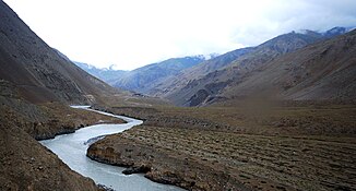
The Spiti is a right tributary of the Satluj in the state of Himachal Pradesh in northwest India .
The name Spiti means "the middle country" - the land between Tibet and India.
The Spiti arises at the confluence of several source rivers (Kunzum La Togpo and the Kabzima and Pinglung streams) near Lossar in the western Himalayas . In the upper section, the Spiti flows through the Spitital named after it , a high mountain valley with little vegetation and a predominant desert climate , in a predominantly south-southeastern direction. The main Himalayan ridge runs west of the hospital. The upper reaches lie within the sub-district Spiti . Here the river passes the main town Kaza . Then he picks up the Lingti from the left and the pin from the right. In the middle section, the Spiti turns to the east and passes the village of Tabo. The Spiti flows through the Kinnaur district on the lower 90 km . At Sumdo he picks up the Parechu from the left and now turns south. It passes Nako and flows into the Satluj at Khab. The Spiti has a length of 200 km. A road follows the river for its entire length.
