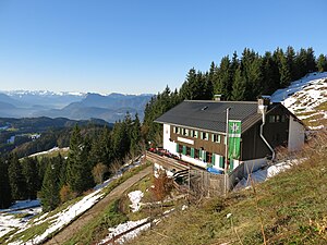
Spitzsteinhaus
| Spitzsteinhaus DAV hut category II |
||
|---|---|---|
|
Pointed stone house from the northeast |
||
| location | on the south side of the Spitzstein ; Tyrol , Austria ; Valley location: Erl | |
| Mountain range | Chiemgau Alps | |
| Geographical location: | 47 ° 42 '15 " N , 12 ° 14' 35" E | |
| Altitude | 1252 m above sea level A. | |
|
|
||
| owner | DAV - Section Mountain Friends Munich | |
| Construction type | hut | |
| Usual opening times | All year round | |
| accommodation | 20 beds, 50 camps | |
| Web link | Site of the hut | |
| Hut directory | ÖAV DAV | |
The Spitzsteinhaus is a mountain hut the section mountaineers Munich of the German Alpine Club in 1252 meters altitude on the south side of the pointed stone . It is located in the Chiemgau Alps in the municipality of Erl in the Tyrolean district of Kufstein, just a few meters from the state border with Bavaria . The shelter is open and managed all year round. The area is known for the mostly avalanche-safe conditions. The Spitzsteinhaus is a base on larger tours through the Chiemgau Alps, on the Königssee-Bodensee long-distance hiking trail, the Maximiliansweg and the Via Alpina and the Chiemgautour.
Accesses
- From the parking lot on the Erlerberg (950 m) via the Goglalm, easy, walking time: 1 hour
- From the parking lot on the Goglalm (1,150 m) to the Spitzsteinhaus in just 15 minutes
- From Sachrang (740 m) via Mitterleiten or via Mesneralm each 1½ hours
- From Innerwald (710 m) via the Mesneralm and Aueralm, easy, walking time: 1½ hours
Transitions
- Klausenhütte (1,510 m), (the hut is closed!) Via Brandelberg and Feichtenalm , medium, walking time: 3 hours
- Riesenhütte (1,345 m) via Klausenhütte and Abergalm , medium, walking time: 4½ hours
- Hochrieshütte (1,570 m) via Klausenhütte and Abergalm, medium, walking time: 5 hours
- Priener Hütte (1,410 m) via Sachrang (740 m), easy, walking time: 4 hours
Mountaineering
- Spitzstein (1,600 m), easy hut summit, walking time: 1 hour
- Brandelberg (1,515 m) via Aueralm, medium, walking time: 1½ hours
Web links
Individual evidence
- ^ Bergfreunde-Muenchen.de: Bergfreunde Munich

