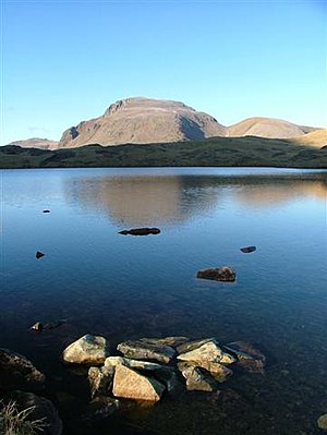
Sprinkling tarn
| Sprinkling tarn | ||
|---|---|---|

|
||
| Sprinkling Tarn with Green Gable on the right and Great Gable on the left in the background | ||
| Geographical location | Lake District , Cumbria , England | |
| Drain | unnamed to the Styhead Tarn | |
| Data | ||
| Coordinates | 54 ° 28 '18 " N , 3 ° 11' 34" W | |
|
|
||
| Altitude above sea level | 598 m | |
| length | 260 m | |
| width | 214 m | |
| Maximum depth | 9 m | |
The Sprinkling Tarn is the name of two lakes in the Lake District , Cumbria , England . To the south of the lakes lies the Great End Fell and to the north the Glaramara and Seathwaite Fell .
The larger of the two lakes has no recognizable above-ground tributary, its unnamed short outlet flows into the Styhead Tarn , making it one of the sources of the River Derwent .
A second smaller lake ( 54 ° 28 ′ 0 ″ N , 3 ° 11 ′ 1 ″ W ) only a little southeast of this lake is referred to as Sprinkling Tarn on the maps of the Ordnance Survey , but it has no connection to the other lake and no recognizable Inflow or outflow is.
The Sprinkling Tarn is located east of the Sty Head Pass and can be reached via this from Borrowdale , Wasdale but also Eskdale , as well as via a path from Geat Langdale to the east .
