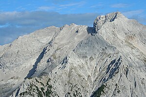
Spritzkarspitze
| Spritzkarspitze | ||
|---|---|---|
|
The Spritzkarspitze (left) and Eiskarlspitze (right) from the south |
||
| height | 2606 m above sea level A. | |
| location | Austria | |
| Mountains | Hinterautal-Vomper chain , Karwendel | |
| Dominance | 0.75 km → Eiskarlspitze | |
| Notch height | 87 m ↓ on the ridge to the Eiskarlspitze | |
| Coordinates | 47 ° 22 '52 " N , 11 ° 33' 4" E | |
|
|
||
| Type | Felsberg | |
| rock | Wetterstein lime | |
| Age of the rock | Middle Triassic | |
| First ascent | Hermann von Barth on September 2, 1870 from the south through the Spritzkar | |
The Spritzkarspitze ( 2606 m above sea level ) is a mountain in the Karwendel in the Hinterautal-Vomper chain . It falls to the north of the Eng-Alm with 800-meter-high wall runs through which numerous climbing routes lead.
topography
The Spritzkarspitze is connected by rocky ridges with the Eiskarlspitze in the southeast and with the Plattenspitze in the west-southwest ( 2492 m above sea level ). The north-facing cliffs are divided into a north-west and a north-east wall by the north pillar, roughly in a summit fall line. The Eiskarln are embedded in the wall fragments facing northeast . Towards the south, the Spritzkarspitze generally drops less steeply into the Spritzkar and Vomper Loch .
Ascent and routes
Climbing the summit requires at least climbing grade II on the UIAA scale . The technically easiest climb is the south-facing path of the first climber Hermann von Barth through the Spritzkar . However, this route is considered to be arduous and difficult to find on the descent. The ascent from the north through the Eiskarln, like the transition to the Plattenspitze, is also in the II degree.
Some of the most important climbing routes lead through the north side. The Schiefe Riss , which O. Bauriedl and A. Holzer started for the first time in 1902, with the difficulty V- was the most important climbing tour in the Karwendel at the beginning of the 20th century. The north edge (V +) was climbed by L. Bauer and G. Gruber in 1924. The straight north-west face (IV) is also used more often .
Individual evidence
- ↑ Heinrich Schwaiger: The Karwendel Group , in: The development of the Eastern Alps , Volume I, Verlag des DOeAV, Berlin 1893
literature
- Heinrich Klier and Fritz März, Alpine Club Guide Karwendelgebirge , Bergverlag Rudolf Rother , 12th edition, Munich 1984, ISBN 3-7633-1200-5 .
- Alpine Club Map 1: 25,000: 5/2 Karwendel Mountains Middle , 2008 edition.

