
St. Michaels, Maryland
| St. Michaels | |||
|---|---|---|---|
| Nickname : The Town that Fooled the British | |||
Location in Maryland
|
|||
| Basic data | |||
| Foundation : | 1804 | ||
| State : | United States | ||
| State : | Maryland | ||
| County : | Talbot County | ||
| Coordinates : | 38 ° 47 ′ N , 76 ° 13 ′ W | ||
| Time zone : | Eastern ( UTC − 5 / −4 ) | ||
| Residents : | 1,020 (as of 2012) | ||
| Population density : | 342.3 inhabitants per km 2 | ||
| Area : | 3.24 km 2 (approx. Err mi 2 ) of which 2.98 km 2 (approx. 1 mi 2 ) are land |
||
| Height : | 3 m | ||
| Postcodes : | 21663 | ||
| Area code : | +1 410 | ||
| FIPS : | 24-69825 | ||
| GNIS ID : | 591218 | ||
| Website : | stmichaelsmd.com | ||

St. Michaels is a city in Talbot County in the state of Maryland in the United States with 1020 inhabitants (2012).
geography
The town lies at the mouth of the Miles River in the Chesapeake Bay on the Delmarva Peninsula , 15 kilometers west of the Countyverwaltung ( County Seat ) Easton and around 80 kilometers east of Washington, DC
history
In 1677, an episcopal church was founded on the banks of the Miles River and named after the Archangel Michael . The place was active in shipbuilding from the beginning. On August 10, 1813, British sailors approached the city in barges to bomb the city. In the evening, however, the residents switched off all the lights in the houses and only lit lanterns far outside in the trees. The cannon fire then missed the targets in the city. Only the building still known today as Cannonball House was slightly damaged. After this successful defense, the residents of St. Michaels sometimes referred to themselves as "the inventors of military blackout" and nicknamed the city The Town that Fooled the British .
Today St. Michaels has developed into an idyllic fishing town with a wide range of small inns specializing in the preparation of the blue crabs found in Chesapeake Bay . Various water sports activities are also offered for tourists.
Several historically valuable buildings and places are listed on the National Register of Historic Places , including the Cannonball House, the Old Inn, Saint Michaels Mill, and the Saint Michaels Historic District.
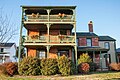
Dodson House

Eagle House
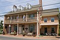
Old Inn

Saint Michaels Mill

Chesapeake Bay Maritime Museum
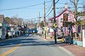
Downtown

Cannonball House

Saint Michaels Historic District


Demographic data
In 2012 a population of 1020 people was determined, which means a decrease of 14.5% compared to 2000. The average age of residents in 2012 was 50.2 years, well above the Maryland average of 41.7 years, which indicates that the city is increasingly used as a retirement home. 12.3% of today's residents are of German origin.
Individual evidence
Web links
- Museum - Chesapeake Bay Maritime Museum