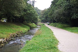
St Austell River
|
St Austell River White River |
||
|
Shortly before the mouth at Pentewan. |
||
| Data | ||
| Water code | GB : GB108048002280 | |
| location | Cornwall | |
| River system | St Austell River | |
| source | Northwest of Carthew 50 ° 22 ′ 42 " N , 4 ° 49 ′ 25" W. |
|
| muzzle | For Pentewan coordinates: 50 ° 17 '22 " N , 4 ° 46' 48" W 50 ° 17 '22 " N , 4 ° 46' 48" W. |
|
| Mouth height |
0 m ASL
|
|
| length | 20.8 km | |
| Catchment area | 37.47 km² | |
| Right tributaries | Gover Stream, Polgooth Stream | |
| Medium-sized cities | St Austell | |
| Communities | Treverbyn, Valley of Pentewan | |
| Navigable | No | |
|
Estuary at Pentewan. |
||
The St Austell River is a 13 miles long river in Cornwall , England . Its catchment area is 37.47 square kilometers.
course
The St Austell River rises on the southern edge of the Hensbarrow Beacon , the highest point of the Hensbarrow . The first town he passes is Carthew in Treverbyn Parish . Approximately in the middle of its course on its eastern, left bank lies the city center of the eponymous St Austell . Here the Gover Stream flows towards it from the west. Next he reaches the Parish Valley of Pentewan . In this section it is accompanied by a cycle path that was laid out on the route of the former Pentewan Railway . The Polgooth Stream, the most important of its tributaries, flows from the west near the hamlet of London Apprentice. Finally, he reached the harbor town of Pentewan where he into the English Channel counting Megavissey Bay opens.
Status
The upper reaches of the St Austell River runs through a landscape that is heavily influenced by the mining of kaolin . The light color of the rock gives it its second name White River , which means white river . A formerly common name was Red River , Red River , caused by the operating in the area, but set mining of tin and copper . In 2006, the owner Imerys announced that he would reduce the area he needed for the kaolin opencast mine by around 700 hectares in the coming years . As a result, work began on renaturing the area on the upper reaches of the river .
The lower reaches of the river have been straightened , which leads to recurring problems from erosion on the bank areas.
Web links
- St Austell River on the UK Environment Agency website
- River Catchments - St Austell Stream or White River on the Cornwall Rivers Project website
Individual evidence
- ↑ The Rivers Par, St Austell & Caerhays, Cornwall on the Westcountry River Trust website, accessed April 1, 2018.
- ^ About the eco-communities project. Information about the project on the UA Cornwall website, accessed on April 5, 2018. (English)

