Stadelsbach
| Stadelsbach | ||
| Data | ||
| Water code | DE : 23863236 | |
| location |
Swabian-Franconian forest mountains
|
|
| River system | Rhine | |
| Drain over | Blind red → Kocher → Neckar → Rhine → North Sea | |
| source | in the barn field at the southwestern foot of the Hohenberg 48 ° 59 ′ 59 ″ N , 10 ° 2 ′ 14 ″ E |
|
| Source height | approx. 503 m above sea level NHN | |
| muzzle | at the Bühlerzeller Röhmensägmühle from the left and northeast into the middle blind red coordinates: 48 ° 59 ′ 10 ″ N , 10 ° 0 ′ 0 ″ E 48 ° 59 ′ 10 ″ N , 10 ° 0 ′ 0 ″ E |
|
| Mouth height | approx. 425 m above sea level NHN | |
| Height difference | approx. 78 m | |
| Bottom slope | approx. 19 ‰ | |
| length | 4.1 km | |
| Catchment area | approx. 3.7 km² | |
The Stadelsbach is a brook in the Ellwang Mountains in the northeast of Baden-Württemberg , predominantly in the area of the municipality of Rosenberg in the Ostalbkreis , which after a four-kilometer run to the southwest, last at the Röhmenmühle in the municipality of Bühlerzell in the Schwäbisch Hall district from the left flows into the middle blind red , whose longest tributary it is.
geography
course
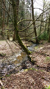
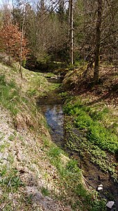
The Stadelsbach rises in the municipality of Rosenberg at the foot of the 568.9 m above sea level. NHN high Hohenberg about 400 meters southwest of the pilgrimage church on the summit of this round mountain in a spring basin at about 503 m above sea level. NHN . The stream runs through four ponds right at the beginning on its permanently south-westerly course. Almost a quarter of a kilometer after the running area, behind the last of the ponds, he enters a large closed forest area that now accompanies him for most of his run. On the right, the Gewann Kohlhau borders the brook, on the left the Gewanne Ganserswald , then Stadelsbach and finally Hirschreute separate from each other. In the forest, the Stadelsbach first takes up the 0.7 km long Gansersbach , shortly before its exit into the corridor around its receiving water, then the Grundbach , which is twice as long ; both fed the Stadelsbach from the east. After recording the last one, the Stadelsbach runs through the municipal area of Bühlerzell on its last half kilometer on the left side of the Blinde-Rot-Lauf . At the Röhmensägmühle it flows to about 425 m above sea level. NHN in the middle blind red .
The 4.1 km long Stadelsbach with an average bed gradient of about 35 ‰ flows 144 meters below its source.
Catchment area
The catchment area of the Stadelbach is about 3.7 km² and, in terms of natural space , is located in the lower area of the Ellwanger Mountains of the Swabian-Franconian Forest Mountains . Occurring in the catchment layer sequence of this Keuper bergland ranges from pebbles sandstone ( Hassberge formation ) or higher up into the Upper Keuper , at the highest point on the Rundling top of the top flashy flat High Mountain maybe even up to the forming in the area often Verebnungen Black Jura . Up there is also the 568.9 m above sea level. NHN highest point of the catchment area, which is not even a meter lower than the highest of the entire Ellwang Mountains.
With the exception of the eastern edge of the catchment area, where there is mostly an open field around the Hohenberg, and on an even smaller area in the estuary there is closed forest in the catchment area, which largely belongs to the Rosenberg community in the Ostalbkreis . The only place near the run is the Röhmensägmühle residential area near the mouth, around it a small part of the lower catchment area belongs to its municipality of Bühlerzell in the Schwäbisch Hall district .
Tributaries and lakes
List of tributaries and ![]() lakes from source to mouth. Length of water, lake area, catchment area and altitude according to the corresponding layers on the LUBW online map. Other sources for the information are noted.
lakes from source to mouth. Length of water, lake area, catchment area and altitude according to the corresponding layers on the LUBW online map. Other sources for the information are noted.
Origin of the Stadelsbach in the municipality of Rosenberg at about 503 m above sea level. NHN in a basin about 400 meters southwest of the pilgrimage church on the Hohenberg ( 568.9 m above sea level ) in a basin. The stream runs with many changes in direction and partly in very narrow meanders throughout to the southwest.
-
 Flows through on the first 200 meters of its course to the entrance to the forest at about 490 m above sea level. NHN four ponds, a total of 0.2 ha.
Then it turns right almost all the way to the Waldgewann Kohlhau , on the left first the Waldgewann Ganserswald . -
Gansersbach , from the left and east to about 470.6 m above sea level. NHN a good kilometer after the origin, 0.7 km and about 0.2 km². Here a noticeably wide cleared aisle crosses the valley along a forest path.
-
 Flows at about 495 m above sea level. NHN a small pond on the edge of the forest west-southwest of the Gansershof of the Zumholz farm group , under 0.1 ha.
 -
 After a short eastward run it flows through to about 490 m above sea level. NHN a reservoir closer to the Gansershof, 0.3 ha, which it leaves on the west course.
-
-
 For the next good kilometer there are springs on the right slope, first the Häulesbrunnen , then the two rock springs of the high well , the first of which is initially in an oxbow lake at about 460 m above sea level. NHN of the Stadelbach flows away, well below 0.1 ha.
 - Grundbach , from the left and east to about 446 m above sea level. NHN at the exit of the forest a little before the Röhmensägmühle, 1.4 km and about 0.9 km². Arises at about 475 m above sea level. NHN at the reforested Sperberswiese . To the right and above the Grundbach inlet, the Waldgewann Stadelsbach now borders the stream of the same name, while to the left of the Grundbach is the also wooded Hirschreute .
Estuary of the Stadelbach from the left and northeast to approx. 425 m above sea level. NHN at the Röhmensägmühle von Bühlerzell in the middle blind red . The Stadelbach is 4.1 km long and has a catchment area of around 3.7 km².
Nature and protected areas
The Stadelbach flows quite naturally on the larger part of its course between the left tributaries Gansersbach and Grundbach . From the Gansersbach inlet, a forest path accompanies him.
A water protection area is almost congruent with the catchment area of the Stadelbach. Around the second right slope spring, called Hochbrunnen , a 0.2 hectare area of extensive natural monument Hochbrunnen am Stadelbach has been set up on the middle course . The little crotch estuary near an open corridor in the Röhmensägmühle part of the protected landscape Upper Blind Red Valley .
Individual evidence
LUBW
Official online waterway map with a suitable section and the layers used here: Course and catchment area of the Stadelbach
General introduction without default settings and layers: State Institute for the Environment Baden-Württemberg (LUBW) ( notes )
- ↑ a b c Height according to the contour line image on the background layer topographic map .
- ↑ a b Length according to the waterway network layer ( AWGN ) .
- ↑ a b Catchment area measured on the background layer topographic map .
- ↑ Lake area after the layer standing waters .
- ↑ Height according to black lettering on the background layer topographic map .
- ↑ Protected areas according to the relevant layers.
Other evidence
- ↑ Wolf-Dieter Sick : Geographical land survey: The natural space units on sheet 162 Rothenburg o. D. Deaf. Federal Institute for Regional Studies, Bad Godesberg 1962. → Online map (PDF; 4.7 MB)
- ↑ Hansjörg Dongus : Geographical land survey: The natural spatial units on sheet 171 Göppingen. Federal Institute for Regional Studies, Bad Godesberg 1961. → Online map (PDF; 4.3 MB)
- ↑ Geology roughly based on: Map server of the State Office for Geology, Raw Materials and Mining (LGRB) ( notes )
literature
- Topographic map 1: 25,000 Baden-Württemberg, as single sheet No. 6926 Stimpfach and No. 7026 Ellwangen (Jagst) West
Web links
- Map of the course and catchment area of the Stadelbach on: State Institute for the Environment Baden-Württemberg (LUBW) ( information )
- Map of the course and catchment area of the Stadelbach on: Geoportal Baden-Württemberg ( information )
- Measuring table sheet Ellwangen from 1935 in the Deutsche Fotothek (without the northernmost catchment area around the Hohenberg)


