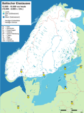
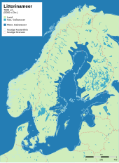
Stages of the Baltic Sea in the postglacial
With the thawing of the ice layers of the Vistula Ice Age, various predecessor seas formed in the area of today's Baltic Sea . These processes, known as the stages of the Baltic Sea in the postglacial , were the prerequisite for the formation of the Baltic Sea around 10,000 years BC. Chr .; the development took place after the melting of the Fennoscan Ice Sheet over various freshwater / brackish water and salt water lakes.
Before the current geomorphological formation of the Baltic Sea was reached, large depressions and lakes filled with meltwater had formed, which temporarily found access to the sea, were sealed off from the sea and finally established today's connection to the North Sea via the Kattegat and merged with the incoming salt water mixed. From a geological point of view, the Baltic Sea is a very young sea, whose current shape and character emerged over several intermediate stages as an interplay of glacier melt, land elevation and sea level rise.
Subglacial lake
The area of the Baltic Sea already formed a huge subglacial lake in northern Europe several millennia before the cold maximum of the last glacial period , which was covered by glaciers .
Retreat of the glaciers
About 10,000 to 8200 BC As a result of the climatic change at the time, the Scandinavian glaciers withdrew towards the inland. When the ice edge was at the height of today's Åland Islands northeast of Stockholm after the ice masses had melted, a large meltwater basin, the Great Baltic Ice Reservoir , formed in its foreland.
From around 8200 BC. The sea level rose further, so that a connection to the ocean was formed in the area of today's central Swedish lake district . The resulting fresh water outflow and salt water inflow formed what is known today as the (salty) Yoldia Sea .
From around 7000 BC. The Scandinavian glaciers thawed even further back in the 3rd century BC, the pressure on the Scandinavian land mass decreased, it began to rise, which led to the existing sea connection being blocked. The salt water content decreased drastically and the (sweet) Ancylussee was created .
Around 6000 BC Until about the year 0, the sea level rose due to the so-called Littorina transgression so that the mainland bridge between southern Sweden and Denmark was flooded and the east of Denmark was divided into today's islands. The access near the Darßer Schwelle off the German coast opened up, in the southern area of the Baltic Sea the rough forms of today's coasts developed. The mainland of Scandinavia continued to rise after the almost complete retreat of the glaciers. The southern part of the Baltic Sea sank, the sea advanced and flooded the young glacial landscape, new mainland lines formed. As a result, there are three coastal forms in the southern area: Förden coast (example: Kieler Förde ), bay coast (example: Lübeck Bay ) and the lagoon or lagoon compensation coast (example: Fischland-Darß-Zingst peninsula ) z. Sometimes with the formation of harbors (example: Stettiner Haff ).
Uplifts and subsidence
The processes mentioned led to large-scale geological and hydrographic processes: since the earth's crust is not rigid, long-term exposure (such as the 3,000 m thick Scandinavian inland ice) causes the earth's crust to bend. When the load is relieved, the earth's crust bulges with a delay due to the tenacity of the magma; with the melting of the Soft Ice Age inland ice, there is consequently a glacial-isostatic compensatory movement with land uplifts in the center of the glaciation and subsidence in the outer areas. Even today, Scandinavia is rising by around 9 mm per year.
Another influencing factor are the climate-dependent (eustatic) changes in water level. The more water is bound in the ice masses of the mainland, the lower the world sea level. In the Vistula high glacial the sea level was 80–100 m lower than today. The melting of the inland ice immediately led to a relatively rapid rise in the water level. This interaction of land elevation and sea level rise decisively determined the late and post-glacial history of the Baltic Sea, the development of which is divided into four main stages, which are characterized by the change of connection to the ocean with different salinity: Baltic Ice Reservoir, Yoldia Sea, Ancylus Sea and Littorina Sea (as well as as a subdivision the "Limnea Sea" and the "Mya Sea").
The predecessor lakes / seas of the Baltic Sea
Tabular overview of the development stages
| designation | time | water | Display organisms |
| End of the Vistula Ice Age | ~ 10,000 BC Chr. | - | - |
| Baltic ice reservoir | ~ 10,000-8000 BC Chr. | sweet | - |
| Yoldia Sea | ~ 8000-7700 BC Chr. | salty - brackish | named after the saltwater mussel Yoldia arctica (now Portlandia arctica ) |
| Ancylussee | ~ 7500-6000 BC Chr. | sweet | named after the freshwater snail Ancylus fluviatilis |
| Littorina Sea | ~ 6000 BC Chr. - year 0 | salty - brackish | named after the periwinkle Littorina littorea |
| Limnea Sea | ~ 0–500 AD | salty - brackish, but light sweetness | named after the brackish water snail Limnea ovata |
| Myameer | ~ 500 AD to the present | salty - brackish | named after the sand clam Mya arenaria |
Baltic ice reservoir (10,000–8,000 BC)
After the two to three kilometers thick Scandinavian ice layer of the Vistula Ice Age began to melt around 14,000 years ago, several ice reservoirs developed from the meltwater behind the ice barrier . United to the large Baltic ice reservoir . This freshwater lake stretched from the island of Møn to Lake Ladoga without reaching today's German Baltic coast. Bornholm and the Danish islands were still mainland. When the edge of the ice retreated from the central Swedish terminal moraines, the freshwater lake ran out in batches through the central Swedish depression that had become free and connected to the ocean. The penetrating salt water mixed with the glacier water, especially in the Stockholm area and the Gotland Basin. The other areas of the inland lake became brackish .
Yoldia Sea (8000-7700 BC)
Due to the eustatic sea level rise caused by the melting of the glaciers, there was a connection to the North Sea for about 300 years and more salt water penetrated the Baltic Sea area again. This exchange of water brought the mussel Yoldia arctica (now Portlandia arctica ) into the now brackish to salty water, which earned it the name Yoldia Sea (from approx. 8000 BC). This phase is characterized by the fact that in the course of time the glacial-isostatic rise in Scandinavia has become greater than the climate-dependent rise in sea level.
Ancylussee (7500-6000 BC)
The Ancylussee was in turn an inland lake , named after the key fossil Ancylus fluviatilis , a freshwater snail. It was created around 9,500 to 8,000 years ago when the Scandinavian mainland was further relieved of the weight of the ice; this led to an isostatic renewed land uplift of up to nine millimeters / year (which still lasts today), whereby the central Swedish connection to the sea closed again about 9500 years ago. The Ancylussee drained over a river in the Great Belt area . The western Baltic Sea area was still mainland at that time. Between Darßer Ort and Swine the Ancylus-Großsee reached at its highest level in several places on today's Polish and German Baltic coast. Initially the outflow was via central Sweden, but the outflow shifted to the south as a result of the isostatic uplift in Scandinavia and the simultaneous sinking of the southern areas. Here the masses of water formed a great river that scoured its bed deep . Can be seen today in the Kadetrinne in the Darßer Schwelle as well as in the channels in the Fehmarnbelt and the Great Belt.
Littorina Sea (6000 BC - year 0)
Due to the increased amount of meltwater , a narrow headland finally separated the North Sea (with a level 30 meters below today's level) from the slightly higher-lying Ancylussee .
Due to the high pace of the eustatic sea level rise and the continuous uplift in Scandinavia, the formerly mainland areas in the Atlantic and subboreal regions in the entire southern Baltic Sea area were literally "drowning", with the entire south-western Baltic Sea area being completely flooded and the connection to the ocean being re-established . The salty water penetrated eastwards across the Belt Sea , forming the salty brackish Littorina Sea , named after the brackish water snail Littorina littorea , beginning around 8000 years ago . Due to the high rate of rise, the early Litorina Sea penetrated far and deep into the glacial hollow forms. These included u. a. the narrow tongue-shaped basins of the Schleswig-Holstein fjords and the particularly deeply carved and enclosed glacier tongue basins of the Western Pomeranian coastal area.
Limnea and Mya Sea (0–500 AD to the present)
During the subatlantic , i.e. the last 2000 years, the Baltic Sea became increasingly sweet due to the constant supply of river water. In addition, the narrowing of the Danish gates led to a reduced influx of salt water. The older section of this epoch is called “Limnea Sea” after the brackish water snail Limnea ovata ; the last 1,500 years are named after the brackish sand clam Mya arenaria as the "Mya Sea".

Baltic Sea today
The Baltic Sea (also Baltic Sea ) is now a 412,500 km² inland sea in Europe up to 459 m deep and is considered the second largest brackish water sea in the world , even if the western Baltic Sea ( Belt Sea) mostly has a higher salt due to the water exchange with the North Sea - and oxygen content can be observed. The geophysical processes of land uplift and sea rise (the latter also due to climate change ) are still going on. The "zero line" runs today near North Jutland over southern Skåne and north Bornholm in the direction of the Gulf of Finland. To the north of it is an uplift area, to the south of it a subsidence area ("bathtub effect"). This results in z. In Finland, for example, land increases by 10 km² annually. Scandinavia is still rising by around 9 mm per year.
See also
literature
- Svante Björck: The late Quaternary development of the Baltic Sea. Pp. 1-23
- Matti Tikkanen, Juha Oksanen: Late Weichselian and Holocene shore displacement history of the Baltic Sea in Finland. Fennia 180: 1-2; Pp. 9-20; Helsinki 2002; ISSN 0015-0010
Individual evidence
- ↑ a b c d e f g h i Christian Voigt: Origin of the Baltic Sea, Geographie Infothek Edition 2012. Website Klettverlag Leipzig, accessed on April 6, 2015 .
- ^ Svante Björck: A review of the history of the Baltic Sea, 13.0-8.0 ka BP. In: Quaternary International 27, 1995, pp. 19-40, doi: 10.1016 / 1040-6182 (94) 00057-C .
- ↑ a b c d Robert Spielhagen: The emergence of the Baltic Sea. Geomar website, January 1, 2012, accessed April 6, 2015 .
- ↑ a b c d Ulrich Neumann: Inland Sea Baltic Sea. Planet Wissen website, August 15, 2014, accessed April 6, 2015 .
- ↑ S. Unverzagt: Spatial and temporal changes in areas with oxygen deficiency and hydrogen sulfide in the deep waters of the Baltic Sea. Edited by the Geographical Institute of the Ernst-Moritz-Arndt University of Greifswald. Greifswald 2001 (= Greifswald Geographical Works. Volume 19), p. 5.
- ↑ Björn Hillmann: Sea level fluctuations from the Ice Age to the future Geographical Institute of the University of Kiel; Summer semester 2004; On: ikzm-d.de (PDF; German; 209 KB)


