Hengsen reservoir
| Hengsen reservoir | |||||||
|---|---|---|---|---|---|---|---|
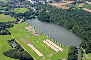
| Aerial photo (2015): View over the reservoir with Geisecke (top left) and NSG Bahnwald (right) | |||||||
|
|||||||
|
|
|||||||
| Coordinates | 51 ° 27 '44 " N , 7 ° 38' 35" E | ||||||
| Data on the structure | |||||||
| Data on the reservoir | |||||||
| Altitude (at congestion destination ) | 110 m | ||||||
| Water surface | 0.192 km² | ||||||
| Reservoir length | 1055 m | ||||||
| Reservoir width | 182 m | ||||||
The Hengsen reservoir is a reservoir on the Ruhr for drinking water .
description
The lake is located north of the Ruhr river and in the south of the municipality of Holzwickede . The Bahnwald nature reserve borders directly to the north of the lake . In the middle of the lake is a small island, which used to be covered with trees, with an area of approx.
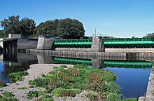
In contrast to the five large Ruhr reservoirs , the main course of the Ruhr flows alongside the lake. The Ruhr is dammed up over a weir to fill the lake . The area between the reservoir and the Ruhr forms an island. It is also known as "Hengsen Island" among water management experts and hydrologists.
The name of the lake comes from the Holzwicked district of Hengsen , in which the lake is located. When the lake was built, Hengsen was still an independent municipality. In Schwerte it is also known as Geiseckersee , as it borders directly on Schwerte- Geisecke . The ornithologists also refer to it in their observation reports as Geisecker See or Geiseckesee .
The lake and other surrounding properties belong to the Hengsen waterworks of the Dortmund Energy and Water Supply (DEW). As part of the waterworks operation, the lake is used for sedimentation and groundwater recharge .
History of the lake
The lake was created in 1937 to obtain water. The agricultural and tourist use of the surrounding area has been reduced further and further by legal regulations on drinking water protection. While in the 1950s the Ruhr / Lappenhausen house , located in the immediate vicinity of the lake, was still a leisure meeting point with restaurants, all buildings were leveled by DEW by 1973.
Nature and tourism at Lake Hengsen
The use of drinking water for the production of drinking water sets very tight limits to the tourist use today. At the beginning of the lake in the west, a promenade leads along the shore and offers a view of the idyllic lake with its island.
This quiet location also favors the endangered wildlife. A breeding colony of cormorants has existed on the island in the reservoir since 1993, but their concentrated excrement largely destroyed the vegetation on the island over the course of 15 years.
See also
Web links
swell
- ^ Test field Insel Hengsen (Institute for Water Research GmbH) ( Memento of the original dated August 3, 2007 in the Internet Archive ) Info: The archive link was automatically inserted and not yet checked. Please check the original and archive link according to the instructions and then remove this notice.
- ↑ https://www.ruhrgebiet-industriekultur.de/stausee-hengsen.html
- ↑ The development of the island vegetation for the years 1969 (full treetops), 1998 (still some green can be seen) and 2006 (completely dead) can be seen well on aerial photo excerpts from the historical association Holzwickede .


