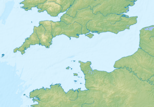
Strait of Alderney
| Strait of Alderney | ||
|---|---|---|
| Connects waters | English Channel | |
| with water | English Channel | |
| Separates land mass | Alderney | |
| of land mass | Cotentine | |
| Data | ||
| Geographical location | 49 ° 43 '4 " N , 2 ° 4' 7" W | |
|
|
||
The Strait of Alderney ( en. Alderney Race , fr. Raz Blanchard nrm. L'Raz ) is a waterway in the English Channel between La Hague and the channel island of Alderney. One of the strongest tidal currents in Europe can be found in the waterway . It is a changing current that can be predicted very precisely. The name Blanchard ( fr. Blanc = white) is due to the fact that the troubled sea is covered with foam. The English name is derived from the channel island Alderney, where English is the official language. The Strait of Alderney forms the northern limit of the Passage de la Déroute and the north-eastern limit of the Gulf of Saint-Malo .
speed
The current speed can reach 12 knots at spring tide.
The northern limit of the Strait of Alderney is a mile or two north of a straight line connecting Quénard Point in Alderney to the La Hague lighthouse. The troubled zone extends to the east as far as the Basse-Bréfort buoy near the port of Omonville-la-Rogue . To the south, the boundary of the troubled zone is delineated by a straight line between the Schôle Shoal , which is halfway between the northeast point of Guernsey and the Cape of La Hague, and the Cape of Flamanville .
The flood current flows to the northeast, the maximum corresponds approximately to the flood time in Cherbourg . The ebb current flows to the southwest, and the maximum corresponds approximately to the ebb time in Cherbourg. The change in current corresponds roughly to the half-flood times in Cherbourg. The greatest speed is measured about a mile southwest of the La Hague lighthouse at Buje la Foraine . The maximum tide speed varies between six and twelve knots, the maximum ebb speed between four and nine knots.
State of the sea
When the wind blows against the current, the sea is extremely rough. The wave troughs can reach two to four meters. The distance between the waves is less than 50 m. When the wind and the tidal current are in the same direction, the sea becomes calmer. To make matters worse, the bottom of the lake is not smooth, on the contrary, it is very rough. Alderney and La Hague are geologically in the Armorican massif .
When adverse conditions prevail, the rich foam is blown away by the wind, which makes visibility worse.
Even in good weather conditions and opposite swell and current - in particular the shallows as the schole -Untiefe or Longis Bay on the southeast coast of Alderney - there is wave breaking. Especially in foggy weather, when the sounds are better transmitted by the air, the breaking of the waves can be heard very well at a distance of two to three miles.
Hydrography
The strength of the current can be explained by the following factors:
- The distance between Alderney and La Hague is only eight nautical miles. The road forms a restriction between the Gulf of Saint-Malo and the rest of the English Channel
- The difference in water level is great:
- the tide is higher and earlier at Carteret than at Cape La Hague (an average of 2 meters and 40 minutes) with a distance of 22 miles.
- At Cape La Hague the tide is higher and earlier than Cherbourg (an average of 2 meters and 30 minutes) with a distance of 14 miles.
This constellation causes the rise of the water. English-language nautical charts speak of "Dangerous Overfalls" in the case of the Race of Alderney .
Channel Islands
Other minor streets of Guernsey :
- The Swinge ( fr. Passage au Singe ) between Alderney and Burhou
- Little Roussel ( fr. Petit Ruau ) between Guernesey and Herm
- The Gouliot ( fr. Le Gouliot ) between Sark and Brecqhou
Renewable energy
The French government is investigating the construction of ocean current power plants in the Strait of Alderney (just as on the Raz de Barfleur , also on the Cotentin coast ) in one of the strongest tidal currents in Europe between the Cape of La Hague and Alderney.
As part of the development of renewable energies, an HVDC connection is planned between England and L'Étang-Bertrand (on the Cotentin peninsula ), which could land in Siouville-Hague .
At the same time, low-level radioactive wastewater from the La Hague reprocessing plant (and the adjacent Center de stockage de la Manche ) is discharged from Herqueville into the Strait of Alderney , which could lead to conflicts between nuclear power and renewable energies . Also, Hurd's Deep is close by.
Individual evidence
- ^ Raz Blanchard Wikimanche.
- ↑ Dictionnaire ATILF .
- ^ Courants de marée, Service hydrographique et océanographique de la marine, Ouvrage ISBN 2-11-088197-6 .
- ↑ en: The Swinge (English).
- ↑ en: Little Roussel (English).
- ↑ Renewable energies developpement-durable.gouv.fr, mars 2013. see in particular p. 46.
- ↑ West Normandy Marine Energy (in English).
- ↑ [1] (in French).
- ↑ Réseau de transport d'électricité ( Memento des original of December 26, 2014 in the Internet Archive ) Info: The archive link has been inserted automatically and has not yet been checked. Please check the original and archive link according to the instructions and then remove this notice. (in French).
- ↑ Anse des Moulinets website www.laradioactivite.com (in French).
- ↑ Anse des Moulinets website Greenpeace (in French).

