Route 24
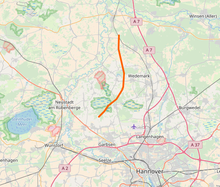
The track 24 is a historic 35 km long motorway project the autobahn in the province of Hanover , now part of Lower Saxony .
The construction of the route planned by the association to prepare the Hansestädte – Frankfurt – Basel ( HaFraBa ) road began in 1938, but was discontinued a few years later. The construction of the motorway is nowhere far advanced, but its course can still be traced today. Some structures are still standing and anomalies can be seen in the local landscape or in aerial photographs.
course
Route 24 was originally supposed to lead west of Hanover from today's route at the Allertal rest area near Westenholz (map) .
The division of the autobahn into a western and an eastern branch was planned in order to reach Bremen in the west as well as cities such as Braunschweig , Gifhorn , Salzgitter or Wolfsburg in the east, which the unexplored eastern branch should pass. You should first walk past Buchholz (Aller) and then cross a bridge over today's street Am Bahnhof , which connects Grindau and Hope ( Lindwedel ). At the point where the abutments stood until 1995 , a short, pointless-looking bulge on the otherwise dead-straight street can still be seen today (map) .
A few meters further to the southwest there is a trench crossing over the Grindau , where the route was planned at that time (map) .
After two more passages, the route crosses the street In Rodenbostel between Ibsingen and Rodenbostel (map) . Bridge piers also stood there until the 1960s. Individual dams, the material of which was taken from the surrounding gravel works , can also be seen on the route. In the forest of the Brelinger Mountains , some concrete parts follow to the south.
After a junction to the southwest, you can see a swath in the forest on aerial photos between Negenborn and Brelingen (map) .
Finally, north of Resse, the only part of the street that can actually be recognized as a street is the street Schießplatz (map) .
From the end of this road, the course is marked over a length of about 1.2 kilometers to the westernmost settlement of Resses by a series of moor lakes that were created by the inflow of groundwater into the excavated soil of the route (map) .
After that, there are no more signs of route 24, which should continue to today's A 2 in Garbsen .
panorama
See also
- Route 46
- Route 77
- Route 85
- Reichsautobahn Vienna – Breslau
- Reichsautobahn Berlin – Königsberg
- Unfinished structures
Web links
- Route on OpenStreetMap
- Michael Grube: The forgotten motorway near Hanover on the Geschichtsspuren.de page [o. D.] the interest group for historical military, industrial and transport buildings
- Hinrich Burmeister (Responsible): The forgotten Autobahn (pdf) on the wedemark.de website


