
Szydłów (Powiat Staszowski)
| Szydłów | |||
|---|---|---|---|

|
|
||
| Basic data | |||
| State : | Poland | ||
| Voivodeship : | Holy Cross | ||
| Powiat : | Staszów | ||
| Gmina : | Szydłów | ||
| Area : | 1.62 km² | ||
| Geographic location : | 50 ° 35 ' N , 21 ° 0' E | ||
| Height : | 300 m npm | ||
| Residents : | 1109 (2012) | ||
| Postal code : | 28-225 | ||
| Telephone code : | (+48) 41 | ||
| License plate : | TSZ | ||
| Economy and Transport | |||
| Street : | Ext. 765 Chmielnik - Osiek, ext. 756 Rzepin - Stopnica | ||
| Next international airport : | Krakow-Balice | ||

Szydłów is a town and seat of a town-and-country municipality ( gmina miejsko-wiejska ) in Poland in the Świętokrzyskie Voivodeship about 43 km southeast of Kielce and 13 km west of the district town of Staszów . In 2006 the community had 4906 inhabitants. The main town above the valley of the Ciekąca brook is also known as the Polish Carcassonne because of its preserved city walls .
history
The first written mention of Szydłów dates from 1191. The chronicler Jan Długosz mentions the place in connection with the Tatar invasion in 1241 as a city. The city is also mentioned under the princes and kings Bolesław Wstydliwy , Władysław I. Ellenlang and Casimir the Great . Under Casimir the Great, of whom seven visits to the city are documented, the city walls with three city gates (Cracow, Opatów and Water Gates) and the pseudo-two-aisled Gothic St. Ladislaus Church, one of the six Barycka churches (expiatory churches for the murder of the priest Marcin Barycka, who had warned the king about immoral conduct), as well as the fortified castle was built. Various guilds emerged in the 14th and 15th centuries. In 1528 a water supply with a Ruhrhaus was built. From the middle of the 16th century onwards, a considerable Jewish community emerged and a stone synagogue was built at the same time. A conflagration devastated parts of the city in 1565, as did in 1630. In 1655, most of the buildings were destroyed by Swedish and Hungarian troops and most of the residents were killed. The city did not recover from this blow. In 1777 there was an armed uprising against the starost Maciej Sołtyk. In 1793 Szydłów became the seat of the regional court - despite its diminished importance.
In 1795 Szydłów fell to Austria with the Third Partition of Poland . In 1809 it came to the Duchy of Warsaw and was the seat of the district until 1850. In 1815 the place fell to the Kingdom of Poland . In 1822 the city walls were supposed to be auctioned off for demolition, but no buyer could be found. In 1869 Szydłów lost its town charter. After the end of the First World War , in which the place suffered no significant damage, the place came back to the newly formed Poland. The Jewish community, which made up 30% of the total population in 1928, fell victim to the Holocaust . Szydłów was 90% destroyed in military operations at the end of World War II. Reconstruction began immediately after the war. With co-financing from the European Union, extensive renovations began after 2004, for example on the city wall and the market square. On January 1, 2019, Szydłów was restored to town.
local community
The districts of Brzeziny, Gacki, Grabki Duże, Jabłonica, Korytnica, Kotuszów, Mokre, Osówka, Potok, Potok Rządowy, Rudki, Stary Solec, Szydłów, Wola Żyzna, Wolica and Wymysłów belong to Gmina Szydłów. The municipality had 4904 inhabitants in 2006, the eponymous capital 1076 inhabitants.
Attractions
- The St. Ladislaus Church
- The Church of All Saints in front of the Kraków Gate (before 1370)
- The ruins of the Heiliggeistkirche and -spital
- The synagogue (now a communal cultural center)
- The city walls with the Kraków Gate, the Treasury and the Castle

St. Ladislaus Church

Castle
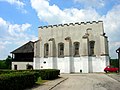
synagogue

Krakow Gate

1.jpg)


literature
- Piotr Walczak, Szydłów – Polish Carcassonne , Gmina Szydłów, 2010.
Web links
Individual evidence
- ↑ Rozporządzenie Rady Ministrów z dnia 25 lipca 2018 r. w sprawie ustalenia granic niektórych gmin i miast oraz nadania niektórym miejscowościom statusu miasta in the Internetowy system Aktów Prawnych, accessed on January 1, 2019.