Türml
| Türml | ||
|---|---|---|
|
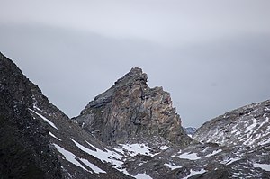
Türml viewed from the east, to the right the Türmljoch |
||
| height | 2844 m above sea level A. | |
| location | East Tyrol , Austria | |
| Mountains | Venediger group | |
| Dominance | 0.23 km → Großer Happ | |
| Notch height | 72 m ↓ Türmljoch | |
| Coordinates | 47 ° 3 '50 " N , 12 ° 18' 54" E | |
|
|
||
| First ascent | July 28, 1913 by Julius Dorn and Th. Husche | |
| Normal way | From the Türmljoch over the western flank | |
The Türml ( 2844 m above sea level ) is a mountain peak of the Dorferkamm in the Venediger group in East Tyrol ( Austria ). It is located in the north of the municipality of Prägraten am Großvenediger . Neighboring peaks are the Kleine Geiger in the west, the Südliche Happ and the Große Happ in the north and the Niklaskopf in the south.
location
The Türml rises as a small rock formation south of the Türmljoch. It is located in the northern part of the Dorferkamm just outside the Hohe Tauern National Park , the border of which begins at the Türmljoch. To the west is the basin of the Stredacher Winkl with the Maurerbach , to the east the Dorfer Bach flows. To the west of the Türml is the Kleine Geiger ( 2815 m above sea level ), south of the Niklaskopf ( 2791 m above sea level ), which can also be reached from the Türmljoch. In the north there is also the double peaks of the Südlicher Happ ( 3304 m above sea level ) and the Großer Happ ( 3352 m above sea level ), a little to the north-east there is also the Kleine Happ ( 2852 m above sea level ). This route was first taken on May 19, 1967 by K. Hoi and W. Almberger.
Promotion opportunities
The ascent to the Türml takes place over the Türmljoch, whereby the ascent from the yoke leads under the east side of the rock structure to the left to a notch to the south. From here the west flank is climbed as far south as possible to the summit, the path leading over steep crags. The ascent from the Türmljoch only takes 20 minutes ( II ). Furthermore, the ascent can also take place via the north edge, but around an hour must be planned here ( IV ).
literature
- Willi End , Hubert Peterka : Alpine Club Leader Venediger Group . 4th edition. Bergverlag Rudolf Rother , 1994, ISBN 3-7633-1242-0 , p. 364
- Alpine Club Map 1: 25,000, sheet 36, Venediger Group , ISBN 3-928777-49-1

