Tagweidkopf
| Tagweidkopf | ||
|---|---|---|
|
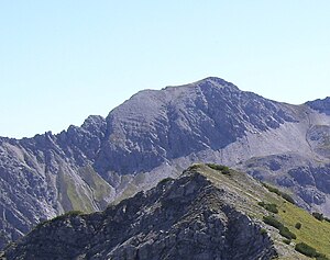
Tagweidkopf from the northwest, on the right the Tagweidjoch, on the left the Tagweidscharte. In the foreground the Hintere Suwaldspitze |
||
| height | 2408 m above sea level A. | |
| location | Tyrol , Austria | |
| Mountains | Lechtal Alps | |
| Dominance | 0.6 km → Loreakopf | |
| Notch height | 83 m ↓ Tagweidjoch | |
| Coordinates | 47 ° 21 '29 " N , 10 ° 46' 37" E | |
|
|
||
| rock | Main dolomite | |
The Tagweidkopf is 2408 m above sea level. A. high mountain in the Lechtal Alps in Tyrol .
Location and surroundings
As part of the Lorea Group, the Tagweidkopf is framed by the Middle Kreuzjoch in the north and the Loreakopf in the south. The sedate summit has a broad scree roof in the northwest, while it breaks off steeply to the west and east. The south side is characterized by moderately steep crags .
The closest places are Mitteregg and Berwang in the northwest and Nassereith in the southeast. The Loreahütte is located nearby .
Ascent
The approach routes to the Tagweidkopf are pathless and require surefootedness . In winter, the summit can be reached on a demanding ski tour .
- From the south over the Tagweidjoch
From the Loreahütte on the hiking trail up to the northwest, but then pathless into the saddle between Loreakopf and Tagweidkopf and on via Schrofen to the summit. The ascent takes about an hour from the Loreahütte.
- From the north over the Tagweidscharte
From the eastern Kreuzjoch, first on the hiking trail over the short ridge, then pathless across the flank of the Mittlerer Kreuzjoch into the gap between this and the Tagweidkopf. From there to the south over the torn ridge ( difficulty II ) to the scree roof and on this further to the summit. This variant takes about an hour from the Ostlicher Kreuzjoch.
Literature and map
- Dieter Seibert: Lechtaler Alpen Alpin, Alpine Club Guide . Munich, Bergverlag Rudolf Rother, 2nd edition 2008. ISBN 978-3-7633-1268-9
- Alpine Club Map : Sheet 4/1 (1: 25,000). Wetterstein and Mieminger Mountains West. ISBN 978-3-928777-19-3

