Takutu (river)
|
Takutu Takutu River, Rio Tacutu |
||
|
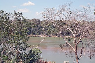
View across the Takutu River from Lethem to Brazil. |
||
| Data | ||
| location | Upper Takutu-Upper Essequibo , Guyana | |
| River system | Amazon | |
| Drain over | Rio Branco → Rio Negro → Amazon → Atlantic | |
| source | Numerous source streams in the hinterland of Upper Takutu-Upper Essequibo and Roraima 1 ° 51 ′ 0 ″ N , 59 ° 42 ′ 0 ″ W |
|
| muzzle | In the Rio Branco coordinates: 3 ° 1 ′ 0 ″ N , 60 ° 29 ′ 0 ″ W 3 ° 1 ′ 0 ″ N , 60 ° 29 ′ 0 ″ W. |
|
| Mouth height |
75 m
|
|
| Left tributaries | Kassuwau, Miliawau, Rio Tiquirre, Kunuwadwau, Igarapé Arraial, Rio Viruquim, Rio Xuá | |
| Right tributaries | Soniwau, Kuwaliwau, Balalawau, Kawali, Mararu, Kamawari, Miruwau, Kowariwau, Shininiwau, Mepitiwau, Roadwau, Ruawau, Dabarwau, Tawarwau, Skabunk, Wakedwau, Kaputwau, Sawouminariwau, Sapaika, Kowar, Inaja | |
| Flowing lakes | Lago do Bicho, Cedral Lake, Lamparina Lake | |
The Takutu (English Takutu River , Portuguese Rio Tacutu , Spanish Río Tacutu , also Itacutu ) is a river in the Upper Takutu-Upper Essequibo region of Guyana and in the state of Roraima in Brazil . For long stretches it forms the border between the two countries. The confluence of the Takutu with the Uraricoera River forms the Rio Branco .
As one of the first Europeans to reach the estuary via the Essequibo in 1739, the Hildesheim doctor Nicholas Horstman (also written as Hortsman) was in the service of the commander of the Essequibo Colony Laurens Storm van 's Gravesande . At the mouth, about 32 km north of the capital Boa Vista , is Forte de São Joaquim do Rio Branco ⊙ , built in the 18th century against the Spaniards from Venezuela who wanted to reach the Amazon via the Rio Tacutu and the Dutch from Suriname via the Rio Uraricoera , today listed ruins. In 1842, at that time the upper reaches belonged to British Guyana , the researcher Robert Hermann Schomburgk traveled the Takutu to the sources. British geologist and topographer Charles Barrington Brown explored Takutu between 1868 and 1871 .
Location area |
geography
The sources of the Takutu River arise in close proximity to the sources of the Essequibo ; in the rainy season, a floodplain forms a connection to the Rupununi River and thus to a tributary of the Essequibo. In the wide plain it cannot be made out which of the streams is the main source. The river initially runs north in wild loops and then enters the savannah area. It forms the Cachoeira Pukalid-pawa waterfalls and passes the Anawundiku hills ( Oxipau waterfalls, Arimera-Kana Falls ), Raad Mountain ( Tawaribar Rapids ). The Chodakerpawa Falls near Raimundo (Brazil) lead the river into agricultural land. In Pium (Brazil), a series of waterfalls follows: Arawanapau , Pauisin case , Pauisparu case , Saruparu case , Poruwanun-Pawa Falls . The river flows around the Kanuku Mountains in the east and at Lethem - Bonfim it enters a heavily populated area for the first time. There it also forms the Lago do Bicho . At Lethem the Moco-Moco flows . A little further north, the river forms Cedral Lake and Lamparina Lake . From the mouth of the Ireng at Conceição do Maú ( Normandia , Roraima), the river turns sharply to the southwest. The Rio Viruquim also flows there . In the lower reaches of the river are numerous small settlements ( Yara , São Benedito , Pôrto Seguro , Maravilha , Carnaúba and Papagaio ).
The state road RR-207 accompanies the upper reaches of the river over long distances on the Brazilian side. In the lower reaches of the federal roads BR-401 (south) and RR-319 (north) run parallel to the river. The Takutu River Bridge creates a year-round navigable connection between Guyana and Brazil. The river flows through traditional residential areas of the indigenous Macuxi .
Web links
Individual evidence
- ^ Robert Schomburgk: Visit to the Sources of the Takutu, in British Guiana, in the Year 1842 . In: The Journal of the Royal Geographical Society of London . tape 13 , 1843, ISSN 0266-6235 , p. 18-75 , doi : 10.2307 / 1798133 , JSTOR : 1798133 .
- ^ Charles B. Brown: Canoe and camp life in British Guiana . London 1876 ( pitt.edu ).
- ↑ Takutu at GeoNames , geonames.org.Retrieved July 15, 2020.


