Rio Negro (Amazon)
| Rio Negro | ||
| Data | ||
| location | Brazil , Venezuela , Colombia | |
| River system | Amazon | |
| Drain over | Amazon → Atlantic | |
| Confluence of |
Río Guainía and Río Casiquiare 2 ° 0 ′ 5 ″ N , 67 ° 6 ′ 59 ″ W |
|
| Estuary ( Encontro das Aguas ) | near Manaus in the Amazon Coordinates: 3 ° 7 ′ 28 ″ S , 59 ° 53 ′ 44 ″ W 3 ° 7 ′ 28 ″ S , 59 ° 53 ′ 44 ″ W
|
|
| length | 2253 km | |
| Catchment area | 720,114 km² | |
| Discharge at the mouth of the A Eo : 720,114 km² |
MQ Mq |
28,400 m³ / s 39.4 l / (s km²) |
| Left tributaries | Rio Branco | |
| Right tributaries | Rio Içana , Rio Uaupés | |
| Big cities | Manaus | |
| Small towns | São Gabriel da Cachoeira, Cacau Pireira | |
| Communities | San Carlos de Río Negro, Cucui, Novo Airão | |
| Ports | Manaus | |
|
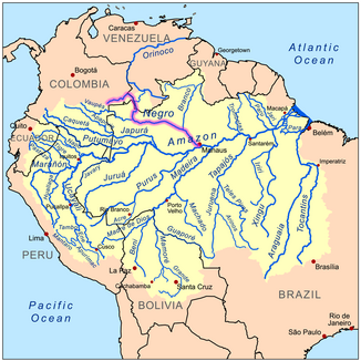
Location and course of the Rio Negro |
||
|
The west-east course of the Amazon with the dark Rio Negro (above) in the satellite image |
||
The Rio Negro ( Spanish Río Negro ; Portuguese and Spanish for "Black River") is the second largest tributary of the Rio Madeira with a water flow of around 28,400 m³ / s and a length of 2,253 kilometers (over Río Uaupés 2,400 km) World. It ranks 60th among the longest rivers in the world , but sixth among the richest rivers . Its headwaters are located in the southwest of the Guiana Mountains in Colombia . The Rio Negro then flows, crossing the equator , in an east-southeast direction through Brazil and flows into the Amazon below Manaus .
River course
Source rivers
The Rio Negro arises from the confluence of the two source rivers Río Guainía , which has been regarded as the upper reaches of the Río Negro since 1884, and the slightly larger Río Casiquiare , which branches off as Brazo Casiquiare from the upper Orinoco flowing north through Venezuela and is the most important river bifurcation of the Earth forms.
The source region of the Río Guainía is located in the southeast of Colombia in the Department of Guainía , from where it initially flows to the east and later turns south to form the border between Colombia and Venezuela . The river basin is very rainy and hardly populated. The course of the river is only slightly cut into the granites and migmatites of the hilly Guayana shield . Occasionally the uppermost Río Negro up to the border with Brazil is also referred to as the Río Guainía.
The Río Casiquiare branches off from the upper Orinoco with a water flow of around 250 m³ / s in the area of a large alluvial fan. Numerous tributaries, especially those coming from the left, allow the river to grow quickly, initially only around 100 meters wide. The largest is the Río Siapá (also Shukuminakëu "Budgerigar River") rich in rapids, with a length of over 410 kilometers. This clear water flow carries more water at the confluence and can be considered the main source of the Río Casiquiare in terms of water volume. It is known as a settlement area for indigenous peoples like the Yanomami and also for its species-rich aquatic fauna. In the catchment area of the second largest tributary, the Río Pacimoni, there is another bifurcation that creates a direct connection to the central Rio Negro.
At San Carlos de Rio Negro , still in Venezuela, but close to the borders with Colombia and Brazil, the Rio Guainía and Rio Casiquiare unite to form the Rio Negro.
Both source rivers seem to be approximately the same size.
Course as Rio Negro
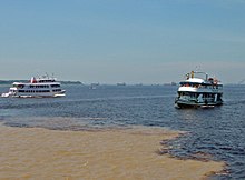
The Rio Negro initially flows in a southerly direction and soon crosses the border to Brazil and its Amazonian state . The confluence of the 1,375 km long Rio Uaupés almost exactly at the equator allows the Rio Negro to take up its eastern direction of flow. The Rio Uaupés has covered another way to the mouth, but is surpassed in water flow by the Rio Negro. After the confluence, the river forms numerous rapids , especially above São Gabriel da Cachoeira (Portuguese: cataract ). About 200 kilometers downstream, 250 km before Manaus, the Rio Negro slows down and branches out. The river reaches a width of over 20 kilometers and flows through an extensive floodplain ( Mariuá Archipelago ) in the Jau National Park , a result of the backwater through the sediment fan below the Rio Branco ( white water river ), which flows into here , where the Rio Negro is barely 1, Narrowed 5 kilometers in width. The current then turns to the southeast and gradually widens again to around 27 kilometers wide, interspersed with islands and banks of the Anavilhanas archipelago , this time due to the backwater of the heavily sedimented Amazon. At Manaus , the river is narrowed to a width of 2.7 kilometers by high banks and crossed by the approximately 3.5 kilometers long Ponte Rio Negro . Near the southern suburbs of Manaus, the Rio Negro unites with the Amazon, which within Brazil bears the name Rio Solimões up to this confluence (known as Encontro das Aguas ) .
Black water
The Rio Negro appears black ( black water river ) because of its high content of humic acids and fulvic acids , which have been washed out of the already heavily leached, sandy soils of the Terra Firme by the rain in its catchment area (720,114 km² ). Black water is strongly colored, but transparent because it does not contain any suspended particles . Almost no plants grow in the nutrient-poor waters, but many dead plant parts get there and decompose. Due to the lack of nutrients, there are hardly any mosquito larvae in the Rio Negro and therefore practically no malaria . In the upper reaches, the Rio Negro also receives clear water rivers from the Guayana mountains. Below the confluence of the Rio Branco, the water is cloudy and brownish.
After the confluence of the Rio Negro, its black water can be distinguished more than 30 kilometers from the milky-brown water of the Amazon.
Source rivers and major tributaries
The Rio Negro has two source rivers:
- Right source river: Río Guainía
- Right tributary: Río Aquio
- Left tributary: Río Conorochite
- Left source river: Río Casiquiare
- Left tributary: Río Siapá
- Left tributary: Río Pasimoni
The largest tributaries of the Rio Negro (from the confluence of the two source rivers) include (downstream):
| Right tributaries | Left tributaries |
|
|
See also
Web links
Individual evidence
- ↑ Maps - Water Resources and Freshwater Ecosystems ( Memento from December 1, 2008 in the Internet Archive )
- ↑ EM Latrubesse et al .: Tropical rivers , Geomorphology 70, pp 187-206, 2005
- ↑ The 7 most water-rich rivers in the world: Amazon , Congo , Lower Meghna , Orinoco , Yangtze , Rio Madeira , Rio Negro; see list of the longest rivers on earth
- ↑ Topographical descriptions and recordings (1884) by a Brazilian-Venezuelan border commission under JF Lopez de Araujo, based on Josef Reindl: The black rivers of South America . In: Münchner Geographische Studien , 13th St., 1903, p. 56 archive.org
- ↑ Note: The information is very inconsistent and varies from a tenth of the Upper Orinoco at low tide to a third at high tide. Information on its mean water flow at Tama-Tama ranges from 1,227 m³ / s to 1,400 m³ / s.
- ↑ Note: There are hydrometric stations on the Casiquiare 23 km above the confluence (Solano) and on the Rio Negro a good 80 kilometers below (Cucui). There are different values for the mean discharge (MQ) for Solano: 2,100 m³ / s ( Global, Composite Runo - Fields Based on Observed River Discharge and Simulated Water Balances ( Memento from January 18, 2012 in the Internet Archive )) and 2,387 m³ / s. ( Informacion Hidrologica - according to MARN ( Memento of November 20, 2011 in the Internet Archive )). Including the catchment areas, the point of confluence shows that in one case the Río Guainía would be the larger river and in the other case the Río Casiquiare. Averaged, the Río Guainía would carry around 2,250 m³ / s of water and the Río Casiquiare around 2,400 m³ / s (Rhine near Emmerich: 2,330 m³ / s).
- ↑ Brazil portal
- ↑ See a NASA satellite image showing the backwater of the Río Negro in front of the alluvial fan of the Río Branco.
- ^ Kümmerly + Frey Rand McNally : International Atlas . Published by Georg Westermann Verlag, ISBN 3-07-508962-1


