Rio Madeira
| Rio Madeira | ||
|
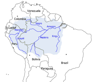
Rio Madeira in the Amazon basin |
||
| Data | ||
| location | Brazil | |
| River system | Amazon | |
| Drain over | Amazon → Atlantic | |
| Start as Madeira | at the confluence of the Río Mamoré and Río Beni west of Nova Mamoré 10 ° 22 ′ 56 ″ S , 65 ° 23 ′ 25 ″ W |
|
| muzzle | above Itacoatiara in the Amazon Coordinates: 3 ° 22 ′ 2 " S , 58 ° 45 ′ 30" W 3 ° 22 ′ 2 " S , 58 ° 45 ′ 30" W
|
|
| length | 1450 km ( with Mamoré , Río Grande , Río Caine , Río Rocha 3,380 km ) | |
| Catchment area | 1,420,000 km² | |
| Discharge at the mouth of the A Eo : 1,420,000 km² |
MQ Mq |
31,200 m³ / s 22 l / (s km²) |
| Left tributaries | Río Abuná | |
| Right tributaries | Rio Jiparaná , Rio Aripuanã , Rio Canumã | |
| Reservoirs flowed through | Santo Antônio dam , Jirau dam | |
| Big cities | Porto Velho | |
| Medium-sized cities | Humaitá , Manicoré , Borba | |
| Navigable | 1100 km | |
|
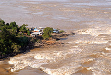
Rio Madeira near Porto Velho |
||
The Rio Madeira is a right tributary of the Amazon in South America . With a discharge of 31,200 m³ / s it is the world's largest tributary . It arises from the confluence of the Río Mamoré and Río Beni east of Nova Mamoré and has a moderately winding, generally northeast-facing course.
River system
The river bears the name Rio Madeira on the lower 1,450 kilometers of the river system . Right from the start it has a water flow of around 18,000 m³ / s. about the size of the Mississippi . At the confluence, the Río Beni is richer in water than the Río Mamoré and thus represents the main hydrographic spring load, the beginning of which lies with the headwaters of the Río Madre de Dios in the Peruvian Andes . The longest source branch is the Río Mamoré with its longest tributary Río Grande ( called Río Caine in the upper reaches ) and its longest source river, Río Rocha . With it, a total length of 3,380 kilometers is given for the Rio Madeira.
Like the Amazon, the Rio Madeira is a white water river . Major parts of its water flow come from the high- precipitation Andean peripheral mountain ranges, which consist of easily erodible sedimentary rocks , so that the flowing waters carry large amounts of suspended matter with them. The abundance of precipitation on the Andean rim decreases from northwest to southeast, which goes hand in hand with the transition from the fully humid tropical rainforest to the semi-arid basins of the Bolivian Andes and which is reflected in the opposite position of the main hydrological branch in the northwest (Río Madre de Dios) and for the longest Quellast (Río Grande) in the savannahs of the southeast.
Economical meaning
The Rio Madeira is navigable over a distance of 1,100 kilometers from the mouth upstream to Porto Velho , the capital of the Brazilian state of Rondônia and the most important port city on the Rio Madeira. The river is an important transportation route for the export of soy from the state of Mato Grosso . An important soy loading station is located in Itacoatiara at the confluence with the Amazon. Above Porto Velho, in the direction of Bolivia , the Rio Madeira is not navigable because of its rapids. The Madeira-Mamoré railway line was once built to bypass it to transport rubber through the tropical rainforest with great loss of life . The line had no connection to other rail lines in Brazil and was abandoned after the end of the rubber boom .
Today the big rapids are blocked by hydroelectric power stations. Of the rapids, the cataracts of Teotônio were at least as important as the famous Boyoma falls in the Congo . The Santo Antônio hydropower plant (3,150 MW) went into operation in 2012 and the Jirau power plant (3,300 MW) in 2013. Together they use a gradient of up to 70 meters. The projects made the idea of an inland waterway from the Río de la Plata to the Orinoco more topical, which could use the two river bifurcations in the north and south of the Amazon basin and would run over the Río Mamoré and the Río Guaporé . The hardly assessable ecological and social consequences of the large-scale projects are criticized. On the one hand, the farmers who cultivate the alluvial land are dependent on the seasonal fluctuations of the river. On the other hand, an unknown number of indigenous peoples live on the banks. Many have already fled to other areas, some came into conflict with miners or loggers who do not always work legally there. Transmitted diseases, against which uncontacted tribes in particular have been unable to develop defenses, can wipe out entire communities. Since the indigenous population was hardly involved in the planning, the projects are also criticized as not being constitutional and not in accordance with Convention 169 of the International Labor Organization ratified by Brazil .
The largest tributaries
The largest tributaries include (downstream):
- Río Abuná (left)
- Rio Jamari (right)
- Rio Jiparaná (right)
- Rio Ipixuna (right)
- Rio dos Marmelos (right)
- Rio Manicoré (right)
- Rio Aripuanã (right)
- Rio Canumã (right)
See also
Web links
Individual evidence
- ^ A b R. Ziesler and GD Ardizzone: The Inland Waters of Latin America COPESCAL Technical Paper No. 1, FAO, Fishery Information, Data and Statistics Service, Rome 1979 ( [1] )
- ↑ Hydrological data of the most important Amazon tributaries (Molinier et al., 1997; PDF file; 810 kB)
- ↑ a b Agência Nacional de Águas (ANA) e Secretaria Nacional de Recursos Hídricos ( data overview )
- ↑ Errata: instead of Manmoré, correct Mamoré ; Río Madre de Dios is nominally (not really) a tributary of the Río Beni
- ↑ Discharge database of the Center for Sustainability and the Global Environment | SAGE | University of Wisconsin-Madison. In: wisc.edu. nelson.wisc.edu, accessed on November 26, 2017 (English, series of measurements from 1970. Series of measurements from 1931 (with greater measurement inaccuracies) come to around 17,000 m³ / s.).
- ↑ Deadly protest at dam construction in Brazil , accessed on August 15, 2013.
- ↑ a b Dams on the Madeira River , accessed August 15, 2013.
- ↑ Convention 169 - Convention on Indigenous and Tribal Peoples in Independent Countries, 1989. In: ilo.org. Retrieved November 26, 2017 .
- ^ Kümmerly + Frey Rand McNally : International Atlas . Published by Georg Westermann Verlag ISBN 3-07-508962-1


