Itacoatiara
| Município de Itacoatiara Itacoatiara |
|||
|---|---|---|---|
|
Aerial view of Itacoatiara
|
|||
|
|
|||
| Coordinates | 3 ° 9 ′ S , 58 ° 27 ′ W | ||
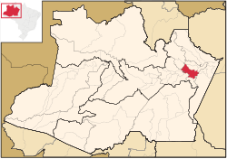
 Location of the municipality in the state of Amazonas Location of the municipality in the state of Amazonas
|
|||
| Symbols | |||
|
|||
| founding | April 25, 1874, 2nd city charter (146 years old) | ||
| Basic data | |||
| Country | Brazil | ||
| State | Amazon | ||
| ISO 3166-2 | BR-AM | ||
| Metropolitan area | Manaus metropolitan area | ||
| structure | 2 districts (since 1960) | ||
| Waters | Amazon | ||
| climate | tropical, Am, Af | ||
| surface | 8,891.9 km² | ||
| Residents | 86,839 (2010) | ||
| density | 9.8 Ew. / km² | ||
| estimate | 101,337 (July 1, 2019) | ||
| Parish code | IBGE : [1] | ||
| Post Code | 69.100-000 | ||
| Telephone code | (+55) 92 | ||
| Time zone | UTC −4 | ||
| Website | itacoatiara.am (Brazilian Portuguese) | ||
| politics | |||
| City Prefect | Antônio Peixoto de Oliveira (2017–2020) | ||
| Political party | PT | ||
| economy | |||
| GDP | 1,978,815 thousand R $ 19,817 R $ per capita (2017) |
||
| HDI | 0.644 (medium) (2010) | ||
Itacoatiara , officially Município de Itacoatiara , is a Brazilian municipality in the state of Amazonas in the metropolitan area of Manaus . The city is the headquarters of the Itacoatiara Territorial Prelature .
geography
It is 176 km east by air or 270 km downstream from Manaus . Itacoatiara is the third largest municipality of the state's 62 municipalities and is located on the banks of the Amazon . The city is known as the "city of painted stone" - as its name translates from Tupi . Itacoatiara has an important port that is responsible for a significant part of the freight transport in the Amazon.
Surrounding communities are Manaus and Rio Preto da Eva in the west, Silves and Itapiranga in the north, Autazes , Careiro and Nova Olinda do Norte in the south, Maué in the southeast , Boa Vista do Ramos and Urucurituba in the east .
The biome is the Amazon rainforest (Amazônia), the climate is tropical equatorial, Am and Af according to the Köppen and Geiger climate classification . The average temperature is 26.9 ° C. The average rainfall is 2261 mm per year. Depending on the source, the height is given as 23, 26 or 40 meters above sea level .
history
Itacoatiara became a separate town by Law No. 74 of December 10, 1857, but in 1858 it was again downgraded to a village called Vila de Nossa Senhora do Rosário de Serpa . Finally, Itacoatiara was raised again on April 25, 1874 to the category of a municipality with the right to self-government with its current name.
Demographics
The current population of Itacoatiara is the result of the intermingling of the three ethnic groups that make up the Brazilian population: indigenous Indigenous Brazilians, Europeans and Africans, thus forming the mestizos of the region ( Caboclos ). Later, with the arrival of other immigrants, particularly the Japanese, Syrians, Lebanese, and Jews who came mainly from Morocco , a unique culture was formed that characterizes the city's population. The majority of the population today is of mixed race, while indigenous people still make up 3 percent of the population.
According to the 2010 census with 86,839 residents, around 67% of the population was concentrated in the urban seat of the municipality, which is just a few square kilometers in size, and around 33% in the extensive remaining municipal area.
Population development
| year | Residents | city | country |
|---|---|---|---|
| 1991 | 58,757 | 37,380 | 21,377 |
| 2000 | 72.105 | 46,465 | 25,640 |
| 2010 | 86,839 | 58,157 | 28,682 |
| 2019 | 101,337 | ? | ? |
 |
|||
Ethnic composition
| group | Share 2000 |
Share 2010 |
annotation |
|---|---|---|---|
| Pardos | 55,826 (77.42%) | 67,813 (78.09%) | Mixed races, mulattos , mestizos |
| Pretus | 1,021 (1.47%) | 2,018 (2.32%) | black |
| Brancos | 13,152 (18.24%) | 16,440 (18.93%) | Whites, descendants of Europeans |
| Amarelos | 75 (0.10%) | 245 (0.28%) | Asians |
| Indigenous people | 286 (0.40%) | 323 (0.37%) | indigenous population |
| without specification | 1,745 | - |
Source: SIDRA database query
photos
Web links
- City Prefecture website , Prefeitura Municipal (Brazilian Portuguese)
- City Council website , Câmara Municipal (Brazilian Portuguese)
- Atlas do Desenvolvimento Humano do Brasil: Itacoatiara, AM , social data
Individual evidence
- ↑ a b IBGE : Itacoatiara - Panorama. Retrieved July 27, 2020 (Brazilian Portuguese).
- ↑ Climate Itacoatiara: Weather, average temperature, weather forecast for Itacoatiara. In: climate-data.org. Retrieved July 27, 2020 .
- ^ Atlas do Desenvolvimento Humano do Brasil: Itacoatiara, AM . Retrieved July 27, 2020.
- ↑ IBGE : Sistema IBGE de Recuperação Automática - SIDRA: Tabela 2093. Retrieved on July 30, 2020 (Portuguese, database query, search terms Itacoatiara (AM) and Cor ou raça).


