Itapiranga (Amazon)
| Município de Itapiranga "Cidade Santa"
Itapiranga
|
||
|---|---|---|
|
|
||
| Coordinates | 2 ° 45 ′ S , 58 ° 1 ′ W | |
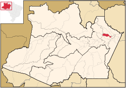
 Location of the municipality in the state of Amazonas Location of the municipality in the state of Amazonas
|
||
| Symbols | ||
|
||
| founding | December 29, 1956 (town charter) (age 63) | |
| Basic data | ||
| Country | Brazil | |
| State | Amazon | |
| ISO 3166-2 | BR-AM | |
| Metropolitan area | Manaus metropolitan area | |
| height | 63 m | |
| climate | tropical, Am / Af | |
| surface | 4,335.1 km² | |
| Residents | 8211 (2010) | |
| density | 1.9 Ew. / km² | |
| estimate | 9,148 (July 1, 2019) | |
| Parish code | IBGE : 1302009 | |
| Post Code | 69120-000 | |
| Telephone code | (+55) 92 | |
| Time zone | UTC −4 | |
| politics | ||
| City Prefect | Denise de Farias Lima (2017-2020) | |
| Political party | PROS | |
| economy | ||
| GDP | 107,576 thousand R $ 11,789 R $ per person (2017) |
|
| HDI | 0.654 (medium) (2010) | |
Itapiranga (officially Portuguese Município de Itapiranga ) is a municipality (municipal city) in the state of Amazonas in the northern Brazilian region . It belongs to the metropolitan area of Manaus . The population was estimated on July 1, 2019 at 9148 inhabitants, who live on a community area of around 4335 km² and are called Itapiranguenser ( itapiranguenses ). The majority concentrate on the urban area of the main town on the Rio Urubu .
Toponymy
Itapiranga is a term of indigenous origin and means red stone .
geography
The surrounding communities are Itacoatiara , São Sebastião do Uatumã and Silves , in the north Presidente Figueiredo .
The biome is the Amazon rainforest (Amazônia). The population lives partly from subsistence farming and extractivism .
climate
The city has a tropical climate, Af according to the Köppen and Geiger climate classification . The average temperature is 27.0 ° C. The average rainfall is 2163 mm per year.
| Jan | Feb | Mar | Apr | May | Jun | Jul | Aug | Sep | Oct | Nov | Dec | |||
| Temperature ( ° C ) | 26.4 | 26.5 | 26.6 | 26.7 | 26.7 | 26.6 | 27.1 | 27.6 | 27.9 | 27.7 | 27.1 | 27.0 | O | 27.0 |
| Precipitation ( mm ) | 290 | 274 | 322 | 264 | 233 | 128 | 118 | 88 | 69 | 93 | 103 | 181 | Σ | 2163 |
Population development
The church is developing slowly. In 2010 around 36% of the population were children and young people up to the age of 15.
| year | Residents | city | country |
|---|---|---|---|
| 1991 | 5,137 | 3,468 | 1,669 |
| 2000 | 7,309 | 5,295 | 2.014 |
| 2010 | 8.211 | 6,451 | 1,760 |
| 2019 | 9,148 | ? | ? |
 |
|||
Source:
Ethnic composition
| group | Share 2000 |
Share 2010 |
annotation |
|---|---|---|---|
| Pardos | 5,604 (76.68%) | 6,375 (77.64%) | Mixed races, mulattos , mestizos |
| Pretus | 39 (0.54%) | 163 (1.99%) | black |
| Brancos | 1,605 (21.95%) | 1,611 (19.62%) | Whites, descendants of Europeans |
| Amarelos | 36 (0.49%) | 55 (0.67%) | Asians |
| Indigenous people | - (0.00%) | 7 (0.08%) | indigenous population |
| without specification | 25th | - |
Source: SIDRA database query
Economic and social data
The monthly average income in 2018 was 1.9 times the minimum wage of real R $ 880.00 (August 2020 conversion: around € 238), the annual gross national product per capita in 2017 was around R $ 11,789 and the human development index (HDI ) in 2010 was the mean value 0.654.
Illiteracy rate
Itapiranga had an illiteracy rate of 20.1% in 1991 , which had already fallen to 11.4% in the 2010 census, and in 2010 43.2% had dropped out of school.
| Illiteracy rate | ||||
|---|---|---|---|---|
| year | percent | |||
| 1991 | 20.12 | |||
| 2000 | 13.80 | |||
| 2010 | 11.35 | |||
Web links
Individual evidence
- ↑ a b c d Itapiranga - Panorama. In: cidades.ibge.gov.br. IBGE , accessed August 7, 2020 .
- ↑ Denise Lima 90 (Prefeita). In: todapolitica.com. Eleições 2016, accessed August 7, 2020 (Brazilian Portuguese).
- ↑ Eduardo Navarro : Método moderno de tupi antigo. A língua do Brasil dos primeiros séculos. 3. Edition. Global, São Paulo 2005.
- ↑ Climate data , accessed August 7, 2020
- ↑ a b c Atlas do Desenvolvimento Humano do Brasil: Itapiranga, AM . Retrieved August 7, 2020 (Portuguese).
- ↑ IBGE : Sistema IBGE de Recuperação Automática - SIDRA: Tabela 2093. Accessed on July 30, 2020 (Portuguese, database query, search terms Itapiranga (AM) and Cor ou raça).

