
Presidente Figueiredo
| Presidente Figueiredo | ||
|---|---|---|
|
Coordinates: 2 ° 3 ′ S , 60 ° 2 ′ W Presidente Figueiredo on the map of the Amazon
|
||
| Basic data | ||
| Country | Brazil | |
| State | Amazon | |
| City foundation | December 10, 1985 | |
| Residents | 32,812 (2010) | |
| City insignia | ||
 |
||
| Detailed data | ||
| surface | 25459.099 | |
| height | 122 m | |
| City structure | 2 districts: Balbina and Pitinga | |
| Waters | Balbina Reservoir and Rio Uatumã | |
| Time zone | UTC −4 | |
| City Presidency | Romeiro José Costeira de Mendonça ( PDT ) (2017-2020) | |
 |
||
 |
||

Presidente Figueiredo , officially Município de Presidente Figueiredo , is a Brazilian municipality in the state of Amazonas . Neighboring cities are in the west Novo Airão , in the north Rorainópolis ( Roraima ), in the east Urucará , São Sebastião do Uatumã , in the southwest Manaus and in the south Rio Preto da Eva . In terms of area, the city is the 37th largest in Brazil and ten times the area of the Saarland . The city is also called the land of waterfalls . The population was estimated on July 1, 2019 at 36,279 inhabitants who live in a community area of around 25,459 km² and are called Figueiredenser.
geography
location
The city is 107 km from the state capital ( Manaus ).
Waters
The community is located on the 2360 km² Balbina Reservoir , which is considered by some to be one of the greatest environmental disasters in the Amazon. The Rio Uatumã , a tributary of the Amazon , feeds the reservoir.
climate
The city has a tropical rainforest climate ( monsoon ), according to the effective climate classification of Köppen and Geiger Af . The annual average temperature is 27.1 ° C. About 2975 mm of precipitation falls annually. There is heavy rainfall during most months of the year. The dry season is short.
|
Monthly average temperatures and rainfall for Presidente Figueiredo
Source: de.climate-data.org
|
|||||||||||||||||||||||||||||||||||||||||||||||||||||||||||||||||||||||||||||||||||||||||||||||||||||
traffic
The BR-174 federal road runs through the city and connects it with Manaus. The state road AM-240 joins the federal road in the city.
economy
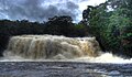
The eco-tourism is an important economic sectors. The Ministry of Tourism has identified over 100 waterfalls and numerous caves in the district.
Average Income and HDI
The average monthly income in 2017 was 3.2 times the minimum wage of 880 reals or around R $ 2,822 (€ 647), the human development index (HDI) was 0.647.

One of the numerous waterfalls
Iracema waterfall

Araras waterfall


Web links
Individual evidence
- ↑ a b IBGE : Presidente Figueiredo - Panorama. Retrieved November 17, 2019 (Brazilian Portuguese).
- ^ Romeiro 12 , website Eleições 2016. Retrieved May 22, 2017 (Portuguese).
- ↑ Climate information , accessed on October 15, 2015
- ↑ IBGE , accessed October 15, 2015
