Tapauá
| Município de Tapauá Tapauá |
||
|---|---|---|
|
|
||
| Coordinates | 5 ° 38 ′ S , 63 ° 11 ′ W | |
 Location of the municipality in the state of Amazonas Location of the municipality in the state of Amazonas
|
||
| founding | 19 December 1955 (city rights) (age 64) |
|
| Basic data | ||
| Country | Brazil | |
| State | Amazon | |
| ISO 3166-2 | BR-AM | |
| height | 102 m | |
| Waters | Rio Purus | |
| climate | tropical, Am / Af | |
| surface | 84,946 km² | |
| Residents | 19,077 (2010) | |
| density | 0.2 Ew. / km² | |
| estimate | 17,156 (July 1, 2019) | |
| Parish code | IBGE : 1304104 | |
| Post Code | 69480-000 | |
| Telephone code | (+55) 92 | |
| Time zone | UTC −4 | |
| Website | tapaua.am (Brazilian Portuguese) | |
| politics | ||
| City Prefect | José Bezerra Guedes (2017-2020) | |
| Political party | MDB | |
| economy | ||
| GDP | 338,818 thousand. R $ 18,897 R $ per capita (2017) |
|
| HDI | 0.502 (low) (2010) | |
Tapauá , officially Município de Tapauá , is a Brazilian municipality in the state of Amazonas . It belongs to the northern region of Brazil , the eponymous capital is on the Rio Purus . With 17,156 inhabitants (estimated in 2019) the municipality is in 34th place and in terms of area with around 84,946 km² (2019) in third place of the 62 municipalities in the Amazon and fifth in Brazil. It only has an extremely low population density and consists mainly of primeval forest. The distance to the capital Manaus is 445 km as the crow flies, the place can be reached by water, it is not accessible by road.
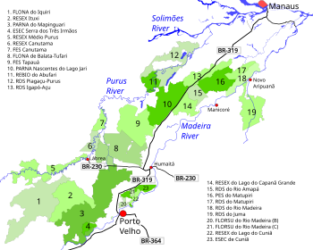
There are several nature reserves and indigenous territories on the territory of this municipality.
geography
Surrounding communities (Munizips) are Carauari and Itamarati in the west, Tefé and Coari in the north, Humaitá and Manicoré in the east, Beruri and Anori in the northeast and Lábrea and Pauini in the south .
history
The municipality formed the District of Boca do Tapauá since December 1, 1938 and was subordinate to the municipality of Canutama . On December 12, 1955, it was renamed Tapauá, received city rights and was spun off from Canutama, which is now to the south.
Tapauá experienced considerable territorial losses in 1981 through the outsourcing of the also independent municipalities of Itamarati (around 25,260 km²), Camaruã and Auxiliadora .
The population lives mainly from extractivism .
Example of a biological reserve in Tapauá, IUCN category Ia .: Reserva Biológica do Abufari
The municipal area includes the Floresta Estadual Tapauá state forest .
Web links
- City Prefecture website , Prefeitura Municipal (Brazilian Portuguese)
- Atlas do Desenvolvimento Humano do Brasil: Tapauá, AM (Portuguese).


