Tamara (Albania)
|
Tamarë Tamara |
||
|
Coordinates: 42 ° 28 ' N , 19 ° 34' E |
||
| Basic data | ||
|---|---|---|
| Qark : | Shkodra | |
| Municipality : | Malësia e Madhe | |
| Height : | 260 m above sea level A. | |
| Telephone code : | (+355) 0211 | |
| Postal code : | 4304 | |
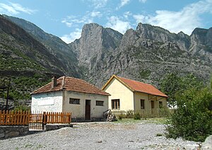
 Tamara houses under the high cliffs of the surrounding mountains |
||
Tamara ( Albanian also Tamarë ) is a place in northern Albania . In the small village is the administrative center of the Kelmend region (Njësia administrative Kelmend) , which was an independent municipality until 2015 , but now belongs to the municipality of Malësia e Madhe .
The place with around 500 inhabitants has a school, a health center, a tourist information office, a church and a small pedestrian zone in the center, which was newly laid out in 2016, also to promote tourism in the region.
geography
Tamara lies within the Albanian Alps in the deeply cut valley of the Cem at around 250 m above sea level. A. In the north-west, the valley rises within around two kilometers to 1500 m above sea level. A. to a ridge on which the border with Montenegro runs. In the south rises 593 m above sea level just above the city . A. high rocks, the beginning of a mountain range, which even at altitudes well over 1000 m above sea level. A. increases. Various caves can be found in the karst mountains around Tamara . Water springs from numerous sources.
Immediately south of the village, the Cem unite with the Cem i Vuklit, which comes from an eastern side valley.
history
The name of the place is derived from the bridge Ura e Tamarës , which Kara Mahmud Pasha, vizier of Shkodra , had built over the Cem i Vuklit in the second half of the 18th century. The population named the bridge in gratitude after his wife Tamara, who suggested that her husband build it after the old bridge was destroyed by a storm.
Tamara used to be the winter pasture of Selca, the historic capital in the valley.
In 1935 the local administration for the Kelmend region took its seat in Tamara. Until after the Second World War , the place consisted practically only of this and had only 116 inhabitants. In January 1945, communist partisans and local nationalist groups fought at the Tamara Bridge. A memorial in the center of the village commemorates over 100 victims of the communist regime among the population of Kelmend. In 1966 the land was collectivized and an agricultural cooperative was set up. A middle school and a hospital were opened in Tamara and a small hydroelectric power station was built.
The Cem valley with Tamara has only been connected to the Albanian road network since 1968. 5000 young people had built a 65-kilometer road to Vermosh in a year and a half .
Economy and Transport
Agriculture and especially livestock are the most important branches of the economy in the place.
Since the end of 2016, the road from Han i Hotit via Tamara and the Qafa e Bordolecit pass to Vermosh has been paved throughout, while the last 500 meters to the border crossing at Gusinje have only a water-bound surface . Tamara has been accessible on a paved road since 2014.
Web links
Individual evidence
- ↑ a b c d Tamara. In: Komuna Kelmend. Accessed February 26, 2018 (English).
- ^ Tourist revival in the Highlands of Kelmend. (No longer available online.) In: Prime Minister's Office. September 17, 2016, archived from the original on February 4, 2018 ; accessed on February 3, 2018 . Info: The archive link was inserted automatically and has not yet been checked. Please check the original and archive link according to the instructions and then remove this notice.
- ↑ a b Kelmend, Albania's northern pearl. In: Tirana Times. October 14, 2016, accessed February 3, 2018 .
- ^ History: Against Communsim. (No longer available online.) In: Komuna Kelmend. Archived from the original on December 24, 2013 ; accessed on February 26, 2018 (English). Info: The archive link was inserted automatically and has not yet been checked. Please check the original and archive link according to the instructions and then remove this notice.
- ↑ Akademia e Shkencave e RPSSH (ed.): Fjalor enciklopedik shqiptar . Tirana 1985, p. 1075 .
- ^ Agim Zeka: Rruga e Malësisë së Madhe . In: Akademia e Shkencave e RPSSH (ed.): Fjalor enciklopedik shqiptar . Tirana 1985, p. 940 f .
- ^ Marianne van Twillert-Wennekes: The new Kelmend road (SH20) in Albania. In: Living in Montenegro :). December 13, 2016, accessed February 3, 2018 .

