
Tanau
|
Tanau
Durlangen municipality
Coordinates: 48 ° 52 ′ 9 ″ N , 9 ° 47 ′ 13 ″ E
|
|
|---|---|
| Height : | approx. 502 m above sea level NHN |
| Residents : | 120 |
| Postal code : | 73568 |
| Area code : | 07176 |
 Tanau from the west. The wooded valley cut of the Klingenbach stretches from the hamlet to the right edge of the picture.
|
|
Tanau is a hamlet with around 120 inhabitants in the municipality of Durlangen in the Ostalb district in eastern Württemberg .
geography
Tanau lies between Spraitbach in the north-west and Durlangen in the south-south-east at an altitude that is a little 502 m above sea level. NHN fluctuates. It stands on one of the Welzheim-Alfdorfer slabs of the Welzheimer forest . On this cleared Black Jurassic plateau extending from northwest to southeast to the Leintal , it is close to its northeastern edge at the origin of the short Klingenbach , which runs through a sharply cut forest valley southeast to east of the "Gmünder" Rot . The district road K 3225 runs through the hamlet of Spraitbach in the direction of Durlangen. From this a lower-ranking street goes on the outskirts to the village of Zimmerbach in the southwest, which also belongs to Durlangen .
history
Tanau is first mentioned as Thanheim in a document from 1360. Until the 15th century it was called Tanheim, from 1525 to 1624 Thana.
Attractions
The Catholic Romanesque sanctuary of St. Anne was built in the 12th century. It contains frescoes from 1425, which were later covered, exposed again in 1949 and restored in 2007/2008. The church also has picture panels depicting the life of Jesus and a Gothic triumphal arch .

Pilgrimage Church of St. Anna
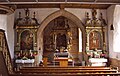
Choir
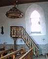
pulpit

Gallery


Individual evidence
- ↑ Hansjörg Dongus : Geographical land survey: The natural spatial units on sheet 171 Göppingen. Federal Institute for Regional Studies, Bad Godesberg 1961. → Online map (PDF; 4.3 MB)
- ↑ Geography according to this detail map on: State Institute for the Environment Baden-Württemberg (LUBW) ( notes )
literature
- Topographic map 1: 25,000 Baden-Württemberg, as single sheet No. 7124 Schwäbisch Gmünd Nord