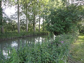
Tarnauds
|
Tarnauds Rivière les Tarnauds |
||
|
The river at Plivot |
||
| Data | ||
| Water code | FR : F6125000 | |
| location | France , Grand Est region | |
| River system | His | |
| Drain over | Marne → Seine → English Channel | |
| Junction from the Somme-Soude | on the municipal boundary of Jâlons and Aulnay-sur-Marne 49 ° 0 ′ 32 ″ N , 4 ° 11 ′ 34 ″ E |
|
| Source height | approx. 74 m | |
| muzzle | on the municipal boundary of Épernay and Chouilly in the Marne Coordinates: 49 ° 2 ′ 16 ″ N , 3 ° 59 ′ 5 ″ E 49 ° 2 ′ 16 ″ N , 3 ° 59 ′ 5 ″ E |
|
| Mouth height | approx. 68 m | |
| Height difference | approx. 6 m | |
| Bottom slope | approx. 0.32 ‰ | |
| length | approx. 19 km | |
Tarnauds ( plural word ) denotes a river in France that runs in the Marne department in the Grand Est region . The river is created on the municipal boundary of Jâlons and Aulnay-sur-Marne through a branch channel from the Somme-Soude , the water supply of which is controlled by weirs . The river generally runs in a westerly direction and flows into the Marne as a left tributary after around 19 kilometers at the municipal boundary of Épernay and Chouilly . On its way, the river runs through a wetland just south of the Montagne de Reims Regional Nature Park .
Places on the river
(Order in flow direction)
