
Jâlons
| Jâlons | ||
|---|---|---|
|
||
| region | Grand Est | |
| Department | Marne | |
| Arrondissement | Châlons-en-Champagne | |
| Canton | Châlons-en-Champagne-2 | |
| Community association | Châlons-en-Champagne | |
| Coordinates | 49 ° 1 ′ N , 4 ° 11 ′ E | |
| height | 72-93 m | |
| surface | 10.35 km 2 | |
| Residents | 561 (January 1, 2017) | |
| Population density | 54 inhabitants / km 2 | |
| Post Code | 51150 | |
| INSEE code | 51303 | |

Jâlons is a French commune with 561 inhabitants (as of January 1, 2017) in the Marne department in the Grand Est region (until 2015: Champagne-Ardenne ); it belongs to the arrondissement of Châlons-en-Champagne and to the community association Châlons-en-Champagne, founded in 2016 . The inhabitants are called Jâlonais .
geography
The municipality of Jâlons is located at the confluence of the Somme-Soude into the Marne , 15 kilometers northwest of Châlons-en-Champagne , 19 kilometers east of Épernay and about 30 kilometers southeast of Reims . The terrain in the 10.35 km² community is flat and swampy in some places ( les Marais ), and apart from the remains of alluvial forest, it is very poorly forested. In the vicinity of the Marne there are some quarry ponds that were created from flooded gravel pits. While few kilometers northwest of Jâlons base wines for champagne in the Vallée de la Marne mentioned portion of the vineyard Champagne are produced, the community Jâlons located in the Champagne sèche , the "dry Champagne" without wine.
Neighboring municipalities of Jâlons are Condé-sur-Marne in the north, Aigny in the northeast, Aulnay-sur-Marne in the east, Champigneul-Champagne in the south and Cherville and Athis in the west.
Place name
In 865 the place appeared for the first time in a document as Villa Gelonis . The name Jalons has been handed down from 1215. From the 16th century the village of Jaalons was written; Jâlons , which is still in use today, has been in effect since 1801 .
Population development
| year | 1962 | 1968 | 1975 | 1982 | 1990 | 1999 | 2006 | 2017 |
|---|---|---|---|---|---|---|---|---|
| Residents | 478 | 530 | 507 | 506 | 449 | 552 | 585 | 561 |
| Sources: Cassini and INSEE | ||||||||
Attractions
- Church Saint-Ephrem with origins from the 11th century, when historique monument reported
- Fallen memorial from 1937
- Former flour mill on the Somme-Soude , Monument historique
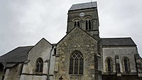
Saint-Ephrem Church

Fallen memorial


Economy and Infrastructure
The central primary school in Jâlons is also responsible for four other villages in the area. There is a doctor's office, a nursing station and a pharmacy in the community, as well as three shops and several craftsmen. A ballroom is available for celebrations.
Jâlons has 15 farms (mainly cereals).
The former Route nationale 3 (now D3) runs through the municipality of Jâlons . The small Jâlons station is on the Paris – Strasbourg line . The next motorway junction is nine kilometers southeast near Châlons-en-Champagne on the Autoroute A26 . There are other road connections to Condé-sur-Marne and Champigneul-Champagne .
supporting documents
- ↑ Auguste Longnon: Dictionnaire topographique de département de la Marne.
- ↑ Jâlons on cassini.ehess.fr
- ↑ Jâlons on insee.fr
- ^ Entry in the Base Mérimée of the Ministry of Culture. Retrieved November 16, 2018 (French).
- ^ Entry in the Base Mérimée of the Ministry of Culture. Retrieved November 16, 2018 (French).
- ↑ Jâlons on paysdechalonsenchampagne.com (French).
- ↑ farms on annuaire-mairie.fr (French).