
Vraux
| Vraux | ||
|---|---|---|
|
||
| region | Grand Est | |
| Department | Marne | |
| Arrondissement | Châlons-en-Champagne | |
| Community association | Châlons-en-Champagne | |
| Coordinates | 49 ° 2 ' N , 4 ° 14' E | |
| height | 73-116 m | |
| surface | 12.8 km 2 | |
| Residents | 460 (January 1, 2017) | |
| Population density | 36 inhabitants / km 2 | |
| Post Code | 51150 | |
| INSEE code | 51656 | |
 Mairie Vraux |
||

Vraux is a French commune with 460 inhabitants (as of January 1, 2017) in the Marne department in the Grand Est region (until 2015: Champagne-Ardenne ). The municipality belongs to the Arrondissement Châlons-en-Champagne and the municipality association Châlons-en-Champagne . The residents call themselves Vrautier .
geography
Vraux is located about 30 kilometers southeast of Reims and twelve kilometers northwest of Châlons-en-Champagne in the Marne river valley . The canal latéral à la Marne , which runs parallel to the Marne to the north, touches the south of the municipality of Vraux. Vraux is surrounded by the neighboring communities of Les Grandes-Loges in the northeast, Juvigny in the southeast, Aulnay-sur-Marne in the south and Aigny in the west and northwest.
A few kilometers northeast of Vraux, the A26 autoroute branches off from the A4 autoroute .
Population development
| year | 1962 | 1968 | 1975 | 1982 | 1990 | 1999 | 2008 | 2017 | |
| Residents | 301 | 315 | 311 | 309 | 329 | 391 | 478 | 460 | |
| Sources: Cassini and INSEE | |||||||||
Attractions
- Saint-Laurent church from the 12th to 15th centuries, monument historique since 1920
- Statues of the Virgin Mary in many niches
- Aircraft Museum ( Musée du terrain d'aviation militaire de Condé-Vraux ) with machines from the Second World War (see below)
- Fallen memorial
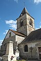
Saint Laurent Church

one of the Marian niches

Broussard , one of the aircraft on display in the museum

Fallen memorial


Condé-Vraux airfield
In the run-up to the Second World War, a military airfield was built north of Vraux , the Aérodrome de Condé-Vraux . Originally built in 1936/37 as a research facility for the French Air Force , it was opened as an airfield on September 3, 1939, the day France entered the war.
In mid-September 1939 the airfield became a station for the British Royal Air Force . Their 15th Squadron, equipped with Fairey Battle , was stationed until the first half of December 1939 and then Condé-Vraux base in Bristol Blenheim became the 114th Squadron. After the German Wehrmacht's western campaign began , the 114th Squadron had to evacuate the airfield in mid-May 1940.
The German Air Force only continued to use the site sporadically, in mid-June 1940 the I. and II. Groups of the Jagdgeschwader lay here with their Bf 109E . In the years that followed, Vraux was only used by the Luftwaffe as an alternative location and it was not until 1944 that the area was prepared for a planned expanded use. In the weeks after the Allied invasion, Bf 109G were lying here.
After the liberation of the area by the Allies, Airfield Y.45 , its Allied code name, became a base of the Ninth Air Force of the United States Army Air Forces . Until mid-May 1945 it served as a base for transport aircraft.
The airfield was abandoned after the war and the terrain was used for agriculture again, only the so-called Maison Rouge reminds of the Condé-Vraux airfield next to the museum located in the village.
Economy and Infrastructure
There are 21 farms in the municipality (mainly grain cultivation, two winegrowers).
The D 1 trunk road from Châlons-en-Champagne to Aÿ-Champagne runs through the municipality of Vraux parallel to the Marneuferd . Ten kilometers to the east and south-east there are connections to the A 4 and A 26 motorways and the motorway-like RN 44 . The Châlons-en-Champagne train station, eleven kilometers from Vraux, is on the Paris – Strasbourg line .
supporting documents
- ↑ Vraux on cassini.ehess.fr
- ↑ Vraux on insee.fr
- ^ Entry in the Base Mérimée of the Ministry of Culture. Retrieved March 23, 2016 (French).
- ↑ Presentation of the Aviation Museum (French)
- ↑ Farms on annuaire-mairie.fr (French)