
Jonchery-sur-Suippe
| Jonchery-sur-Suippe | ||
|---|---|---|
.svg)
|
|
|
| region | Grand Est | |
| Department | Marne | |
| Arrondissement | Châlons-en-Champagne | |
| Canton | Argonne Suippe et Vesle | |
| Community association | Region de Suippes | |
| Coordinates | 49 ° 10 ′ N , 4 ° 29 ′ E | |
| height | 124-151 m | |
| surface | 24.74 km 2 | |
| Residents | 222 (January 1, 2017) | |
| Population density | 9 inhabitants / km 2 | |
| Post Code | 51600 | |
| INSEE code | 51307 | |
 Mairie Jonchery-sur-Suippe |
||

Jonchery-sur-Suippe is a French commune with 222 inhabitants (as of January 1, 2017) in the Marne department in the Grand Est region (until 2015 Champagne-Ardenne ). The municipality belongs to the arrondissement Châlons-en-Champagne and the municipality association Région de Suippes, founded in 2014 . The inhabitants are called macriots .
geography
The municipality of Jonchery-sur-Suippe is located on the Suippe River , about 35 kilometers east-southeast of Reims in the heart of the Champagne sèche , also known as “dry Champagne”, also known as “lousy Champagne” ( Champagne pouilleuse ) or “chalky Champagne” ( Champagne crayeuse ). In contrast to the largely treeless dry Champagne, remains of alluvial forests have been preserved along the course of the Suippe. The area, which has always been unattractive for agriculture, has been used primarily for military purposes since the middle of the 19th century; so is the southwestern half of the 24.74 km² municipal area of Jonchery-sur-Suippe part of the military training area of Camp de Mourmelon and thus military zone. East of Jonchery-sur-Suippe is the Camp de Suippes, an even larger training area. The hamlet of Chantereine belongs to the community . Jonchery-sur-Suippe is surrounded by the neighboring communities of Saint-Hilaire-le-Grand in the north-west and north, Souain-Perthes-lès-Hurlus in the north-east, Suippes in the south-east, Cuperly in the south and Vadenay and Mourmelon-le-Grand in the south-west.
history

The Roman aqueduct that carried water from the Suippe to Reims began in Jonchery-sur-Suippe - underground for the first 44 kilometers. The difference in height was 22 meters. The aqueduct is well documented by excavations carried out between 1988 and 1991.
During the First World War, fierce fighting took place in the Jonchery area. For this reason, one of the many war cemeteries in Champagne is located on the southern edge of the village with 7200 graves .
Shortly after the Second World War there were plans to destroy the community and relocate the residents in order to merge the two large military camps, Camp de Suippes and Camp de Mourmelon . It was not until 1952 that these plans were abandoned.
Population development
| year | 1962 | 1968 | 1975 | 1982 | 1990 | 1999 | 2007 | 2016 | |
| Residents | 177 | 167 | 185 | 186 | 173 | 159 | 169 | 224 | |
| Sources: Cassini and INSEE | |||||||||
Attractions
- Saint-Pierre-ès-Liens church
- Fallen memorial
- Water tower
- Military cemetery of the First World War ( Nécropole nationale ) with ossuary ( Ossuaire )

Saint-Pierre-ès-Liens church and memorial to the fallen
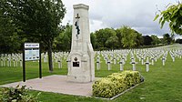
Jonchery War Cemetery

Ossuary of the military cemetery


From the former Fort de Jonchery , only a semicircular wooded wall can be seen on satellite images. It was located in the northeast of the Camp de Mourmelon training area and served as a target for grenades.
Economy and Infrastructure
Eight farms are located in Jonchery-sur-Suippe (cultivation of grain, pulses and oilseeds, cattle breeding). There is also a small winery.
Jonchery-sur-Suippe is on the D 931 trunk road from Reims to Valmy . There is a connection to the A 4 autoroute (Paris-Strasbourg) 18 kilometers south of Jonchery . The train station in Mourmelon-le-Petit, 13 kilometers to the west, is on the Châlons-en-Champagne – Reims railway line .
supporting documents
- ↑ Jonchery's story on cc-regiondesuippes.com (French)
- ↑ Jonchery-sur-Suippe on cassini.ehess.fr
- ↑ Jonchery-sur-Suippe on insee.fr
- ↑ Farms on annuaire-mairie.fr (French)