
Dommartin-sous-Hans
| Dommartin-sous-Hans | ||
|---|---|---|
|
||
| region | Grand Est | |
| Department | Marne | |
| Arrondissement | Châlons-en-Champagne | |
| Canton | Argonne Suippe et Vesle | |
| Community association | L'Argonne Champenoise | |
| Coordinates | 49 ° 8 ' N , 4 ° 47' E | |
| height | 132-203 m | |
| surface | 6.49 km 2 | |
| Residents | 57 (January 1, 2017) | |
| Population density | 9 inhabitants / km 2 | |
| Post Code | 51800 | |
| INSEE code | 51213 | |

Dommartin-sous-Hans is a French commune with 57 inhabitants (as of January 1, 2017) in the Marne department in the Grand Est region (until 2015 Champagne-Ardenne ). The municipality belongs to the arrondissement of Châlons-en-Champagne and to the municipality association L'Argonne Champenoise, founded in 2014 .
geography
Dommartin-sous-Hans is about halfway between Reims and Verdun , immediately west of the Argonne . The community area of six and a half square kilometers is bordered in the northeast by the Bionne , a small tributary of the Aisne . The little relief, almost woodless community area is part of the Champagne sèche , the "dry Champagne", also called "lousy Champagne" ( Champagne pouilleuse ) or "chalky Champagne" ( Champagne crayeuse ). Alluvial forest remains have been preserved along the course of the Bionne; in the southeast the slopes of a long hill called Mont Yvron are covered with trees. At 203 meters above sea level, Mont Yvron is the highest point in the municipality, while the majority of the municipality, which consists mainly of grain fields, is between 140 and 155 m above sea level. Dommartin-sous-Hans is surrounded by the neighboring communities of Courtémont in the north-west and north, La Neuville-au-Pont in the north-east, Maffrécourt in the east, Valmy in the south and Hans in the west.
Population development
| year | 1962 | 1968 | 1975 | 1982 | 1990 | 1999 | 2006 | 2016 | |
| Residents | 97 | 82 | 75 | 70 | 53 | 55 | 53 | 56 | |
| Sources: Cassini and INSEE | |||||||||
Attractions
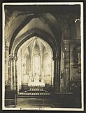
- Saint-Martin church from the 13th century (bell tower from the 11th century), Monument historique
- Lavoir
- Water tower
- Calvaire
- St. Martin Church


Economy and Infrastructure
There are nine farms in Dommartin-sous-Hans that grow grain, pulses and oilseeds. There is also a small winery.
Dommartin-sous-Hans is connected by roads to the municipalities of Courtémont , Maffrécourt , Hans and Vienne-la-Ville . In the town of Sainte-Menehould , nine kilometers away, there is a connection to the A 4 autoroute (Paris-Strasbourg). Sainte-Menehould station is on the Saint-Hilaire-au-Temple-Hagondange railway line .
supporting documents
- ↑ Dommartin-sous-Hans on cassini.ehess.fr
- ↑ Dommartin-sous-Hans on insee.fr
- ^ Entry in the Base Mérimée of the Ministry of Culture. Retrieved May 31, 2019 (French).
- ↑ Farms on annuaire-mairie.fr (French)