Vadenay
| Vadenay | ||
|---|---|---|
|
|
||
| region | Grand Est | |
| Department | Marne | |
| Arrondissement | Châlons-en-Champagne | |
| Canton | Mourmelon-Vesle et Monts de Champagne | |
| Community association | Communauté d'agglomération de Châlons-en-Champagne | |
| Coordinates | 49 ° 4 ′ N , 4 ° 24 ′ E | |
| height | 109-157 m | |
| surface | 19.65 km 2 | |
| Residents | 241 (January 1, 2017) | |
| Population density | 12 inhabitants / km 2 | |
| Post Code | 51400 | |
| INSEE code | 51587 | |
 Vadenay Town Hall ( Mairie ) |
||
Vadenay is a French commune with 241 inhabitants (as of January 1, 2017) in the Marne department in the Grand Est region (before 2016: Champagne-Ardenne ). The municipality belongs to the arrondissement Châlons-en-Champagne and the canton Mourmelon-Vesle et Monts de Champagne (until 2015: canton Suippes ). The inhabitants are called Vadenots .
geography
Vadenay is located about 13 kilometers north-northeast of the city center of Châlons-en-Champagne on the Vesle , into which the Noblette flows here. Vadenay is surrounded by the neighboring communities of Mourmelon-le-Grand in the north and northeast, Jonchery-sur-Suippe in the northeast, Cuperly in the east and southeast, Dampierre-au-Temple in the south, Saint-Hilaire-au-Temple in the southwest and Bouy in the West and northwest.
Population development
| year | 1962 | 1968 | 1975 | 1982 | 1990 | 1999 | 2006 | 2013 |
| Residents | 437 | 164 | 159 | 203 | 226 | 202 | 227 | 260 |
| Source: Cassini and INSEE | ||||||||
Attractions
- Necropolis from the Hallstatt period
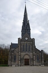
- Saint-Etienne church from the 19th century

