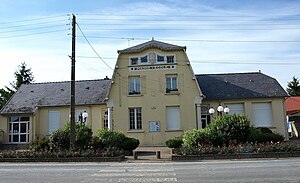
Sainte-Marie-à-Py
| Sainte-Marie-à-Py | ||
|---|---|---|
|
|
||
| region | Grand Est | |
| Department | Marne | |
| Arrondissement | Châlons-en-Champagne | |
| Canton | Argonne Suippe et Vesle | |
| Community association | Region de Suippes | |
| Coordinates | 49 ° 14 ′ N , 4 ° 30 ′ E | |
| surface | 26.92 km 2 | |
| Residents | 198 (January 1, 2017) | |
| Population density | 7 inhabitants / km 2 | |
| Post Code | 51600 | |
| INSEE code | 51501 | |
 Local government |
||
Sainte-Marie-à-Py is a French commune with 198 inhabitants (as of January 1, 2017) in the Marne department in the Grand Est region in the Châlons-en-Champagne arrondissement in the canton of Argonne Suippe et Vesle (until 2015: Canton Suippes ).
geography
The village on the edge of the Ardennes is traversed by the Py . The D20 département road runs through the town .
history

During the First World War , the village was in the battle zone of the Western Front and was badly damaged. At the beginning of September 1914, the region was occupied by the German 3rd Army . After the Battle of the Marne , the German troops retreated north across the Marne . From September 13, 1914, they took up positions south of the town. There was fierce position fighting . The place served as a German supply base. There was also a hospital here . Dead soldiers were buried in the community cemetery. Only at the beginning of October 1918 was Sainte-Marie-à-Py again taken by French troops.
The monument Aux Morts des Armées de Champagne , built in 1923/24 east of the village, commemorates the fighting . The destroyed church in the village was rebuilt in 1927.
Population development
| year | 1962 | 1968 | 1975 | 1982 | 1990 | 1999 | 2005 | 2010 | 2014 |
|---|---|---|---|---|---|---|---|---|---|
| Residents | 291 | 271 | 242 | 243 | 213 | 214 | 202 | 193 | 195 |
| Source: Cassini and INSEE | |||||||||
Web links
Individual evidence
- ↑ Johannes Trimborn, War Diary of Dr. Johannes Trimborn , number 6, Magdeburg City Archives

