Saint-Remy-sur-Bussy
| Saint-Remy-sur-Bussy | ||
|---|---|---|
|
|
||
| region | Grand Est | |
| Department | Marne | |
| Arrondissement | Châlons-en-Champagne | |
| Canton | Argonne Suippe et Vesle | |
| Community association | Region de Suippes | |
| Coordinates | 49 ° 3 ' N , 4 ° 35' E | |
| height | 138-192 m | |
| surface | 34.65 km 2 | |
| Residents | 343 (January 1, 2017) | |
| Population density | 10 inhabitants / km 2 | |
| Post Code | 51600 | |
| INSEE code | 51515 | |
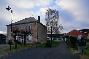
 Town hall ( Mairie ) of Saint-Remy-sur-Bussy |
||
Saint-Remy-sur-Bussy is a French commune with 343 inhabitants (as of January 1, 2017) in the Marne department in the Grand Est region (until 2015 Champagne-Ardenne ). The municipality belongs to the arrondissement Châlons-en-Champagne (until 2017: Arrondissement Sainte-Menehould ), to the canton Argonne Suippe et Vesle (until 2015: canton Givry-en-Argonne ) and to the municipal association Région de Suippes founded in 2014 . The inhabitants are called Saint-Remillons .
geography
Saint-Remy-sur-Bussy is located 25 kilometers east-northeast of Châlons-en-Champagne and about 59 kilometers southeast of Reims . Saint-Remy-sur-Bussy is surrounded by the neighboring communities of Somme-Suippe in the north, Somme-Tourbe in the northeast, La Croix-en-Champagne in the east, Tilloy-et-Bellay in the south and southeast, Somme-Vesle in the south and Bussy -le-Château to the west.
Population development
| year | 1962 | 1968 | 1975 | 1982 | 1990 | 1999 | 2006 | 2011 | 2016 |
| Residents | 317 | 281 | 242 | 266 | 306 | 301 | 334 | 343 | 343 |
| Sources: Cassini and INSEE | |||||||||
Attractions
- Saint-Remi church
Personalities
- Félix Antoine Appert (1817–1891), general and ambassador of France at the Russian court of the tsars

