
Wargemoulin-Hurlus
| Wargemoulin-Hurlus | ||
|---|---|---|
|
||
| region | Grand Est | |
| Department | Marne | |
| Arrondissement | Châlons-en-Champagne | |
| Canton | Argonne Suippe et Vesle | |
| Community association | L'Argonne Champenoise | |
| Coordinates | 49 ° 9 ' N , 4 ° 42' E | |
| height | 131-204 m | |
| surface | 15.17 km 2 | |
| Residents | 46 (January 1, 2017) | |
| Population density | 3 inhabitants / km 2 | |
| Post Code | 51800 | |
| INSEE code | 51659 | |

Wargemoulin-Hurlus is a French commune with 46 inhabitants (as of January 1, 2017) in the Marne department in the Grand Est region (until 2015 Champagne-Ardenne ). The municipality belongs to the arrondissement of Châlons-en-Champagne and to the municipality association L'Argonne Champenoise, founded in 2014 .
geography

Wargemoulin-Hurlus is about 55 kilometers east of Reims , immediately west of the Argonne on the Tourbe , a small tributary of the Aisne , in the northern part of the Champagne sèche , the “dry Champagne”, also “lousy Champagne” ( Champagne pouilleuse ) or “chalky” Champagne "( Champagne crayeuse ) called. The area of the 15.17 km² community has an east-west extension of seven kilometers and is characterized by flat to gently undulating terrain. Only the eastern third of the municipality is inhabited and can be used for agriculture. Here in Tourbetal is the village of Wargemoulin. The center and the west of the municipality are part of the on-site military training area of Suippes ( Camp de Suippes ). In this area lies the former village of Hurlus, which was completely destroyed in the First World War and, like many other villages in the rouge zone, was not rebuilt. Wargemoulin-Hurlus is surrounded by the neighboring communities of Minaucourt-le-Mesnil-lès-Hurlus in the north and east, Laval-sur-Tourbe in the south, Somme-Suippe in the southwest and Souain-Perthes-lès-Hurlus in the west.
history

The area of the municipality was settled early; Excavations in the 19th century unearthed Celtic brooches and torques studded with coral pearls .
Wargemoulin , founded in 1793 as an independent municipality, was first mentioned in 1184 as Wargemolin . Other spellings were Molendinum de Warge-Molin (1208), Vargemolin (around 1300), Verge-Moulin (1306), Varge-Moulin (1461), Wurgemolin (1573), Vurage-Moulin (1711) and Warge-Moulin (18th century ) . Century). Hurlus, which was also founded as an independent municipality in 1793, was called Ursluus in the 11th century , and Ullus and Urlus between 1303 and 1312 . The spellings Urlu and Hurlu have been handed down for 1686 . In 1911, Hurlus still had 88 residents. After the complete destruction in the First World War, only a few remains of rubble remained and it was decided not to rebuild the village. In 1950 the municipal areas of Wargemoulin and Hurlus were merged and the present-day municipality of Wargemoulin-Hurlus was created.
Population development
| year | 1962 | 1968 | 1975 | 1982 | 1990 | 1999 | 2007 | 2016 | |
| Residents | 57 | 55 | 47 | 45 | 48 | 43 | 49 | 46 | |
| Sources: Cassini and INSEE | |||||||||
Attractions
- Saint-Étienne church, built in 1865, damaged in the First World War, reconstructed in the 1930s, Monument historique
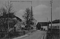
Saint-Etienne church on a postcard from 1913
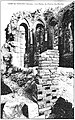
Remnants of the Saint-Remi church in Hurlus


Economy and Infrastructure
Nine farms are located in Wargemoulin (cultivation of grain and pulses).
Wargemoulin-Hurlus can only be reached via the D66 road from Somme-Tourbe to Ville-sur-Tourbe . In the town of Châlons-en-Champagne , 38 kilometers away, there are rail and motorway connections.
supporting documents
- ^ Dictionnaire topographique de la France
- ↑ Wargemoulin on cassini.ehess.fr
- ↑ Hurlus on cassini.ehess.fr
- ↑ Wargemoulin-Hurlus on cassini.ehess.fr
- ↑ Wargemoulin-Hurlus on insee.fr
- ^ Entry in the Base Mérimée of the Ministry of Culture. Retrieved October 31, 2018 (French).
- ↑ Farms on annuaire-mairie.fr (French)