Somme Soude
|
Somme-Soude Somme |
||
|
River course |
||
| Data | ||
| Water code | FR : F6090600 | |
| location | France , Grand Est region | |
| River system | His | |
| Drain over | Marne → Seine → English Channel | |
| source | in the local area of Sommesous 48 ° 44 ′ 13 ″ N , 4 ° 12 ′ 33 ″ E |
|
| Source height | approx. 163 m | |
| muzzle | on the municipal boundary of Jâlons and Aulnay-sur-Marne in the Marne Coordinates: 49 ° 1 ′ 5 ″ N , 4 ° 11 ′ 58 ″ E, 49 ° 1 ′ 5 ″ N , 4 ° 11 ′ 58 ″ E |
|
| Mouth height | approx. 73 m | |
| Height difference | approx. 90 m | |
| Bottom slope | approx. 1.5 ‰ | |
| length | approx. 60 km | |
| Left tributaries | Berle | |
| Right tributaries | Soude | |
|
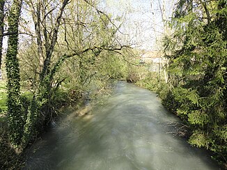
The river at Pocancy |
||
The Somme-Soude (called the Somme in the upper reaches ) is a river in France, in the Marne department in the Grand Est region .
course
It rises under the name Somme in the local area of Sommesous and drains in several large loops in a generally northward direction through the center of Champagne . At Villeseneux the Soude flows into it from the right , from here the river is called Somme-Soude . After a total of around 60 kilometers, the river flows into the Marne as a left tributary at the municipal boundary of Jâlons and Aulnay-sur- Marne . The alluvial or gallery forests along the river create a scenic change in the dry Champagne, which is otherwise poor in woody areas .
etymology
The name of the source town Sommesous is linguistically interesting: Somme , here the name of the river, means "uppermost" and is the first part of the name of several places at the sources of other rivers in Champagne, e.g. B. Sommevesle at the source of the Vesle . And sous means “under”.
Places on the river
(Order in flow direction)
- Sommesous
- House simont
- Vassimont-et-Chapelaine
- Lenharrée
- Écury-le-Repos
- Clamanges
- Villeseneux
- Germinon
- Vélye
- Chaintrix beer stocks
- Vouzy
- Pocancy
- Champigneul-Champagne
- Jâlons

