
Taubertal Bridge
Coordinates: 49 ° 36 ′ 7 ″ N , 9 ° 40 ′ 59 ″ E
|
|
||
|---|---|---|
 |
||
| Official name | Taubertal Bridge | |
| Convicted | Federal highway 81 | |
| Crossing of | Deaf | |
| place | Distelhausen near Tauberbischofsheim | |
| construction | Prestressed concrete - girder bridge | |
| overall length | 661 m | |
| Number of openings | eleven | |
| Longest span | 60 m | |
| start of building | 1967 | |
| completion | 1973 | |
| location | ||
|
||
 |
||

The Taubertal Bridge (officially Taubertal Bridge ) leads the federal highway 81 near Distelhausen , a district of Tauberbischofsheim in the Main-Tauber district in Baden-Württemberg , over the Tauber .
Construction and history
_geschnitten.jpg)
The Taubertal Bridge was built between April 1968 and June 1973. The cost was 12 million marks. Construction work on the nearby Rötenstein Bridge began almost at the same time .
During the construction phase in the 1970s , the additional ceiling construction station Distelhausen was set up to the north of the Distelhausen station for a period of around two years .
The 661 m long Taubertal Bridge has two lanes and one hard shoulder in each direction; In the area in front of the Tauberbischofsheim junction , it has been extended to around 38 m by the deceleration and acceleration lanes on the bridge. It crosses the Tauber at a height of 32 m.
The prestressed concrete - girder bridge has m eleven Fields with Pfeilerachsabständen 60 seconds. It has separate superstructures for each direction of travel, each with a rectangular hollow box girder and a row of hexagonal pillars .
After the Wildbichler Bridge over the Inn near Kufstein, the Taubertal Bridge was the first bridge in Germany to be built using the incremental launching method - with auxiliary piers and still slack reinforced when it was moved.
It was repaired and strengthened between 2010 and 2013. According to experts, a new building will probably be necessary in the 2020s to 2030s despite expensive maintenance.
- Views of the Taubertal Bridge
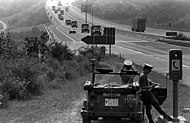
View in southwest direction over the Taubertal Bridge as it is crossed by a United States Army convoy, 1982

View in northeast direction over the Taubertal Bridge to the Tauberbischofsheim junction, 2009

View in northeastern direction under the Taubertal Bridge, 2018


See also
Web links
- A81 Taubertalbrücke near Tauberbischofsheim, 1968 on Karl Gotsch's website
- Taubertal Bridge and Tauberbischofsheim motorway route. Aerial photo in the Baden-Württemberg State Archives
- Taubertal Bridge in km 472.227 abutment A, piers C - M, cantilever superstructure. Historical recording in the Baden-Württemberg State Archives
Individual evidence
- ↑ See the bridge board on the motorway
- ↑ Main Post: Main-Tauber district. Construction sites and construction work on the Taubertal Bridge . August 17, 2010. Online at www.mainpost.de. Retrieved February 22, 2020.
- ↑ a b Fränkische Nachrichten: Autobahn A 81. 40 years ago the construction work on the route was at its peak / A look back (part 1). Pillar by pillar, bridge by bridge . August 8, 2012. Online at www.fnweb.de. Retrieved February 25, 2020.
- ↑ Fränkische Nachrichten: Autobahn A 81. The Rötenstein Bridge near Grünsfeld - a challenging structure / view back (Part II). 18 vehicles put mastic asphalt on the surface . August 15, 2012. Online at www.fnweb.de. Retrieved February 25, 2020.
- ^ A separate station for the material - Franconian news. In: fnweb.de. Retrieved April 28, 2020 .
- ^ Gerhard Mehlhorn (Ed.): Handbook bridges . 2nd Edition. Springer, Heidelberg 2010, ISBN 978-3-642-04422-9 , pp. 839 ( limited preview in Google Book search).
- ↑ Jörg Schlaich, Hartmut Scheef: concrete box girder bridges . IABE - AIPC - IVBH, Zurich 1982, ISBN 3-85748-032-7 , pp. 12 ( limited preview in Google Book search).
- ↑ Uwe Büttner: piece by piece over the abyss. Article from August 6, 2012 on mainpost.de
- ↑ A 81 Repair of the Taubertal Bridge on eautobahn.de
- ↑ Repair of the Taubertal Bridge near Tauberbischofsheim on Destoerungsfrei-pruefungen.de
- ^ Rhein-Neckar-Zeitung: Almost all major bridges on the A 81 in the region have to be rebuilt. They are no longer up to the requirements of the future - the measures will cost the state several billions . August 13, 2016. Online at www.rnz.de. Retrieved February 25, 2020.