Teindeln
|
Teindeln
City of Plettenberg
Coordinates: 51 ° 15 ′ 1 ″ N , 7 ° 48 ′ 42 ″ E
|
||
|---|---|---|
| Height : | 210 (194-230) m | |
| Postal code : | 58840 | |
| Area code : | 02392 | |
|
Location of Teindeln in North Rhine-Westphalia |
||
|
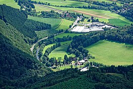
Aerial view of Teindeln
|
||
Teindeln is a district of the town of Plettenberg in the Märkisches Kreis in North Rhine-Westphalia .
location
The small town is about 500 m east of Hilferinghausen and 1 km northwest of Brüninghausen Castle . The federal highway 236 and the main route from Hagen to Siegen, called the Ruhr-Sieg route , run through the town . The Greumecke stream flows through the village and flows into the Lenne on the outskirts .
The Plettenberg-Teindeln industrial park is on the outskirts. The Klef nature reserve is located north of Teindeln. The place is on the Lenneroute cycle path . Pettenberg's lowest point is at 194 m at Teindeln.
history
Archbishop Hermann von Köln enfeoffed Johan von Oele with a castle seat in Bilstein with an estate in Teindeln at that time Tendell , according to a document dated October 9, 1517 . The former St. Nicholas Chapel in Teindeln was no longer used after 1781 and fell into disrepair.
Web links
Individual evidence
- ↑ Historisches Teindeln , accessed on January 8, 2017.

