Tepotzotlán
| Tepotzotlán | ||
|---|---|---|
|
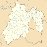
Coordinates: 19 ° 43 ′ N , 99 ° 13 ′ W Tepotzotlán on the map of Mexico
|
||
| Basic data | ||
| Country | Mexico | |
| State | México | |
| Municipio | Tepotzotlán | |
| City foundation | 1525 | |
| Residents | 88,559 (2010) | |
| City insignia | ||
| Detailed data | ||
| height | 2265 m | |
| Time zone | UTC −6 | |
| Website | ||
| Tepotzotlán - Iglesia San Francisco Javier | ||
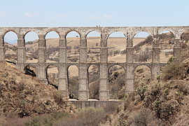
| at Tepotzotlán - Acueducto Arcos del Sitio | ||
Tepotzotlán is a city with about 40,000 and the capital of a municipality ( municipio ) with about 90,000 inhabitants in the north of the state of México . Because of the old center of the city, it is one of the Pueblos Mágicos .
location
Tepotzotlán is located about 45 km (driving distance) north of Mexico City or about 66 km west of the pre-Hispanic pyramid city Teotihuacán at an altitude of about 2265 to 2300 meters above sea level. d. M. The place is on the connecting road (MEX57) from the capital to Santiago de Querétaro .
Population and economy
Only a small part of the community's residents speak the regional Nahuatl dialect; Colloquial language is mostly Spanish. Corn, beans, vegetables, agaves and opuntia are grown in the fields; there are also many small craft workshops and shops. Smaller industrial companies have also settled on the main street.
history
Since around 2500 BC The area around Tepotzotlán is populated by the Otomí people. Around 100 AD, Teotihuacán, about 40 km (as the crow flies) to the east, gained the upper hand in the region. Around 700, Nahuatl-speaking tribes immigrated from the north, including the Chichimecs . Up until the incorporation into the Aztec empire , which grew stronger and stronger in the first half of the 15th century , there were always armed tribal conflicts.
During the conquest of the Aztec Empire by the Spanish conquistadors under Hernán Cortés , Tepotzotlán sided with the Aztecs, which resulted in the early destruction of the city. Around the year 1525 began the Christianization of the Indians, which were soon decimated by diseases such as typhus and smallpox , initially operated by the Franciscan order . The first Jesuits came to the area around 1580 and founded several schools, which earned Tepotzotlán the reputation of the leading educational center in New Spain. However, the year 1767 saw the repeal of the Jesuit order by a decree of Charles III. and the expulsion of the monks from all their settlements. In the course of the Mexican independence movement, Tepotzotlán received municipal status in 1814.
Attractions
- The main attraction of the place is the one built between 1670 and 1682 and dedicated to St. Church of the former Jesuit college, consecrated to Franz Xaver . The facade (around 1750), divided horizontally into three fields, is an important example of the late baroque style des ( churriguerismo ) in Mexico, because the portal zone already shows the pilasters , which are typical of the style, on top and covered with decor ; these are repeated in the window zone and in the gable field . In the niches in between there are figures of saints; in the middle of the gable is a statue of the Virgin Mary. The tower, which dominates the south side of the façade, is barely decorated in the lower part - apart from the embossed stones; However, this changes in the two upper bell-storeys, the corners of which are surrounded by columns and pillars. The tower closes at the top with a ceramic dome with a lantern and a wrought iron cross. The single nave nave of the church has an illuminated crossing dome ; in the apse and in the side chapels there are several late baroque altarpieces, richly decorated with figures and gilded ornamental carvings .
- The former college buildings now contain the Museo de Virreinato with various exhibits on the pre-Hispanic and colonial history and art of the Viceroyalty of Mexico.
- The Iglesia San Pedro Apóstol and the Templo de la Santa Cruz also deserve attention.
Surroundings
- Also worth seeing is the Acueducto de Xalpa (also called Arcos del Sitio ) , which is located around 30 km outside of the village and started by the Jesuits in the 18th century . The approximately 500 m long and maximum 61 m high structure is the tallest of its kind in all of Latin America and forms the visible part of a 41.9 km long aqueduct running from a spring in the mountains to the former Hacienda de Xalpa . In contrast to most of the ancient aqueducts , it is built almost entirely from rubble stones connected by mortar .
Web links
- Tepotzotlán - Photos + Info (Spanish)
- Tepotzotlán - Tourism website (English)


