Schöllenen
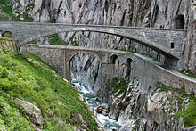
The Schöllenen ( Rhaeto-Romanic ) is a gorge in the Swiss canton of Uri between the communities of Göschenen in the north and Andermatt in the south. The Reuss flows through the gorge . The famous Devil's Bridge leads across the river .
The wild Schöllenen Gorge has always been an obstacle that was difficult to overcome on the route over the Gotthard Pass , which connects the canton of Uri with Ticino . Probably around 1200 there were Walser from the north only through the Bäzberg to reach Urserental which made accessible the canyon for the first time with the construction of daring for its time mule track with several bridges.
Surname
In the past there was a stepped path carved into the rock from the Bäzberg down to the Schöllenen. The point where it joins the gorge is called Steiglen , which corresponds to the Latin word scalineae (= stairs) and the Rhaeto-Romanic word scalina as the origin of the name Schöllenen.
history
Twärren Bridge
Before the first bridge could be built over the Reuss, the Schöllenen had to be developed first. Since the hard rock, falling almost perpendicular to the Reuss, made it impossible to build a solid path, according to tradition, around 1220 a blacksmith from Göschenen or Andermatt came up with the idea of attaching chains to the rock face along the Chilchberg, to which chains protruding from the rock Support beams hung. Boards were placed over these crossbeams, which formed the actual bridge. Another theory about the construction of the footbridge says that crossbeams lying in knocked out niches were stretched from rock to rock, on which the actual boards of the footbridge lay.
It is conceivable that the Walsers played an important role in establishing the path through the Schöllenen. It is believed that they had the technical skills that they acquired while building water pipes ( suonen ) in impassable terrain and building paths and bridges in the steep Valais valleys.
There is no agreement on the exact date of construction. The first recorded description of a trip over the Gotthard dates from the year 1234 and comes from the Bremen canon and abbot Albert von Stade .
The 60-meter-long Twärren Bridge existed until 1707. The name Twärren Bridge comes from the cross-lying timbers over which the path led. The Twärren Bridge is often mistakenly referred to as a floating footbridge . The floating footbridge, however, is another name for the first Devil's Bridge.
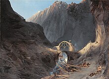
The first devil's bridge
The first wooden bridge over the Reuss was built in 1230. In 1595 it was replaced by a massive stone bridge. After the second bridge was completed in 1830, it was no longer used and left to decay. It collapsed on August 2, 1888. Its foundations are still visible on the north bank of the river.
A replica of the destroyed first stone Devil's Bridge has been standing in the Klein-Glienicke Park in Berlin since 1837 , imitating a crossing of the Alps: the northern part of the park with its forest-like areas represents the German countryside, while the southern part of the park shows more open terrain like in Italy. In between, a mountain range which is considerable by Berlin standards represents the Alps.
The first tunnel: the Urnerloch
However, since the bridge and footbridge were repeatedly damaged by the Reuss - in 1707 a major flood tore the Twärren Bridge away - another way of directing traffic through the gorge was sought. A certificate has still been received which says: “After the rest of the wood that was made of wood has been taken away by an overwhelming waterfall, our commitment is gracious. Lords of Ury have been considered to break through the gählingen bärg, so that in the future the most generous of the imaginary wood may be saved. "
On September 20, 1707, the fortress builder Pietro Morettini , who came from Cerentino in the Valle Maggia and a student of the French fortress builder and architect Vauban , was commissioned to build a new rhinestone through the living rock . The work was to be started within two weeks and carried out to completion, so that one could pass unhindered and freely by spring 1709 at the latest . The contract was signed by Morettini and, in the name of the valley Urssern, Johannes Russi, who was Talammann in the Urserental from 1700 to 1702 .
To everyone's amazement, the 64-meter-long tunnel, the first tunnel on an Alpine road, was finished after eleven months, around August 15, 1708. The engineer had been very annoyed because the heat was black. The costs turned out to be higher than calculated, and not through Morettini's fault: without his effort and loss . According to the contract, it would have been 1680 French thalers , in fact the construction cost 3080. To ensure that Morettini would not suffer any damage, the Urner guaranteed him 1400 French thalers as a deposit . Ursern paid and was allowed to increase the tariffs until the expenses were covered.
A column of sleighs from a train company in the icy Urnerloch (1914–1918)
Second coalition war
During the Second Coalition War , fighting between Napoleonic troops under Claude-Jacques Lecourbe (1758-1815) and Russian troops commanded by General Alexander Suvorov took place in the vicinity of the Schöllenen Gorge on September 25, 1799 . The first Devil's Bridge was badly damaged and impassable. Only over thirty years later was a replacement created with the second Devil's Bridge.
The Suvorov memorial , erected in 1899 and commemorating the battle, stands near the Devil's Bridge .
Second devil's bridge

After the end of the coalition wars in 1815, there was economic hardship in the canton of Uri. Due to a lack of funds, the bridge and pass path could not be made accessible again for the time being, and traffic to the south was increasingly handled via the Splügen Pass . It was not until 1820 that the order for the construction of the second Devil's Bridge could be placed, which was completed after ten years of construction and which still exists today. Today it is used by non-motorized traffic and is part of the north-south route .
Schöllenenbahn
The four kilometer long Schöllenenbahn has been the second transport axis linking Göschenen with Andermatt since 1917. The rack railway has a maximum gradient of 179 per thousand.
Dam wall
Between 1920 and 1944 several projects for hydropower plants were worked out, which would have provided for the construction of a dam wall up to 208 meters high at the Urnerloch. A reservoir would have been created in the Urserental , which would have made it necessary to relocate the villages of Andermatt, Hospental and Realp , which would have affected around 2000 people. Because of the resistance of the local population, the project of an Urseren power plant was abandoned in 1954. Instead, a water intake for the Göschenen power plant was built in the Urnerloch .
Third Devil's Bridge
The second Devil's Bridge and the narrow street were no longer able to cope with the demands of modern traffic in the middle of the 20th century. In 1958 the third Devil's Bridge was opened around 30 meters east of the second bridge and a little higher, which merges directly into the also newly built Fadegg tunnel. With two lanes, she could better absorb the increasing traffic.
A striking image of the devil by the Uri painter Heinrich Danioth , created in 1950 in oil paint, is emblazoned on the rock face above the bridge . In 2008 the red picture was smeared with blue oil paint during an act of vandalism and then extensively restored in the summer of 2009.
Say to the devil's bridge
According to a legend, the first devil's bridge was built by the devil. The people of Uri repeatedly failed to build a bridge. Finally, a landammann called out in despair: "Do sell der Tyfel e Brigg bue!" He would build the bridge and in return he would get the soul of whoever crossed the bridge first. After the devil had built the bridge, the clever Urners sent a billy goat over the bridge. The devil was very angry about this trick and got a stone the height of a house with which he wanted to smash the bridge. But he met a pious woman who carved a cross on the stone. The devil was so confused by God's sign that he missed the bridge when he threw the stone. The stone fell down the entire Schöllenen Gorge to below the village of Göschenen and has therefore been called "Devil's Stone" since then.
In 1973, the Teufelsstein, which weighed around 2,000 tons, was moved 127 meters for CHF 300,000 to make way for the Gotthard motorway . In a modern extension of the folk tale, the shifting of the Teufelsstein is held responsible for the accumulation of traffic accidents at kilometer 4 of the 17 kilometer long Gotthard road tunnel .
Detail from the Scheuchzer map from 1712
literature
- Karl Lüönd : Our Gotthard . Ringier, Zurich 1980, ISBN 3-85859-137-8 .
- Hans Peter Nething: The Gotthard . Ott Verlag, Thun 1976, ISBN 3-7225-6308-9 .
- Werner Meyer : 1291 . Silva-Verlag, Zurich 1990, ISBN 3-908486-47-5 .
- Artur Wyss-Niederer: Sankt Gotthard, Via Helvetica . Edition Ovaphil, Lausanne 1979.
- Ruedi Gisler-Pfrunder: The Devil's Bridge on St. Gotthard . Gisler Druck, Altdorf 2005, ISBN 3-906130-34-7 .
- Hans Stadler: Schöllenen. In: Historical Lexicon of Switzerland . 2011 .
Web links
- Schöllenen on the ETHorama platform
Individual evidence
- ↑ Devil's Bridge on ETHorama
- ↑ Editor: Gotthard Pass. In: Historical Lexicon of Switzerland .
- ↑ Park Klein Glienicke from Other Berlin
- ↑ Erich Haag: Limits of technology: The resistance against the Urseren power plant project. Chronos-Verlag, 2004, ISBN 978-3-0340-0694-1 ( PDF, 3.4 MB [accessed September 29, 2016]).
- ↑ A lift for the poor devil. In: Tages-Anzeiger . May 15, 2009, accessed June 30, 2013 .
- ↑ Helmut Stalder: Dispute about the Teufelsstein: "300,000 francs to the devil" In: Neue Zürcher Zeitung of November 21, 2016
- ^ Iten AG - Teufelstein, 1973 ; according to Swiss television from September 6, 1972 ( memento of the original from July 13, 2014 in the Internet Archive ) Info: The archive link was inserted automatically and has not yet been checked. Please check the original and archive link according to the instructions and then remove this notice. the weight before the shift was given as 1400 tons
Coordinates: 46 ° 38 ′ 51 " N , 8 ° 35 ′ 24" E ; CH1903: 688 141 / 166897


