Thankerton
| Thankerton | ||
|---|---|---|
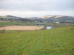
| View over Thankerton | ||
| Coordinates | 55 ° 38 ′ N , 3 ° 38 ′ W | |
|
|
||
| Residents | 521 2011 census | |
| administration | ||
| Post town | BIGGAR | |
| ZIP code section | ML12 | |
| prefix | 01899 | |
| Part of the country | Scotland | |
| Council area | South Lanarkshire | |
| British Parliament | Dumfriesshire, Clydesdale and Tweeddale | |
| Scottish Parliament | Clydesdale | |
Thankerton is a village in the east of the Scottish Council Area South Lanarkshire or in the traditional county of Lanarkshire . It is located around ten kilometers southeast of Lanark on the left bank of the Clyde .
history
At the time of the Scottish King David I (died 1153) a St. Michael's Church was built in the area. Presumably this was at the location of today's Covington Parish Church . This dates from the 15th century and served as the parish church of the community.
Mills were operated in Thankerton in the past. While 290 people were still living in Thankerton in 1961, the 2011 census survey counted 521 residents.
traffic
Thankerton is located off the A73 ( Abington - Cumbernauld ), which connects the village to the trunk road network. On this section it is run together with the A72 ( Galashiels - Hamilton ). The West Coast Main Line , which connects Edinburgh and Glasgow with London , runs through Thankerton . However, the village does not have a train station.
Individual evidence
- ↑ a b Entry in the Gazetteer for Scotland
- ↑ Listed Building - Entry . In: Historic Scotland .
- ↑ Entry on Covington Parish Church in Canmore, the database of Historic Environment Scotland (English)
- ^ Information in the Gazetteer for Scotland
- ↑ 2011 census data

