
Thierberg (Tyrol)
| Thierberg | ||
|---|---|---|
 The Thierberg from Kufstein-Kleinholz |
||
| height | 721 m above sea level A. | |
| location | near Kufstein in Tyrol , Austria | |
| Mountains | Brandenberg Alps | |
| Dominance | 1.06 km → Marbling | |
| Notch height | 70 m ↓ Thierseestraße | |
| Coordinates | 47 ° 36 '0 " N , 12 ° 9' 52" E | |
|
||

The Thierberg is located in the north of the city of Kufstein or southwest of Kiefersfelden and thus extends over the state border between Austria and Germany , but is mostly in Tyrol . On the not too high mountain - the Inn valley is around 500 meters above sea level - there are several lakes: Egelsee , Hechtsee , Längsee and Pfrillsee .
The Thierberg is eponymous for the village and cadastral community Thierberg , which was independent for a long time before it was incorporated by Kufstein.
Thierberg Castle ( 721 m above sea level ) is located on the mountain . It was built by the Freundsbergers around 1280. It later became a popular pilgrimage destination . Next to the ruins is the Thierberg Chapel of the same name, which has been inhabited and cared for by a hermit for centuries. Since the beginning of the 2000s, the castle ruins can be climbed via wooden stairs. On top of the newly built roof you have a 360 ° panoramic view of the Inn Valley. The chapel and the castle ruins can be reached. a. about the Gasthof Neuhaus. From there a 25-minute Way of the Cross leads up. Another path begins at the Hechtsee, from which a forest path first leads to another fork in the path and then over the Ramsau farm to the rear of the castle ruins.
photos

Gasthaus Neuhaus, the ruins in the background

Thierberg Chapel

Thierberg Chapel,
in the background the Spitzstein (left) and the Geigelstein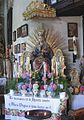
Thierberg Chapel, Marien Altar

Kaiser Mountains seen from the Thierberg


Web links

City center: Festungsberg | Calvary (or Hero's Hill) | Kinkpark | Lausbühel | Zellerberg
City frame: Kaisergebirge (with Stadtberg ) | Pendling | Kufstein Forest | Maistaller Berg | Thierberg (with Marbling )