Tordouet
| Tordouet | ||
|---|---|---|

|
|
|
| local community | Valorbiquet | |
| region | Normandy | |
| Department | Calvados | |
| Arrondissement | Lisieux | |
| Coordinates | 49 ° 3 ′ N , 0 ° 20 ′ E | |
| Post Code | 14290 | |
| Former INSEE code | 14693 | |
| Incorporation | January 1, 2016 | |
| status | Commune déléguée | |
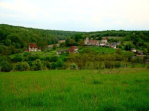
 View of the place |
||
Tordouet ( ) is a former French community with 272 inhabitants (as of 1 January 2013), the Tordouetdictins , in the department of Calvados in the region of Normandy .
On January 1, 2016, Tordouet was incorporated into the new municipality of Valorbiquet as part of a regional reform along with four neighboring municipalities .
geography
Tordouet is located in the Pays d'Auge . Lisieux is located around 14 kilometers north-northwest of the village . Bernay , east-northeast, is a good 22 kilometers away. The Orbiquet runs northeast of Tordouet.
Population development
| year | 1793 | 1836 | 1876 | 1926 | 1946 | 1975 | 1990 | 2013 |
| Residents | 1,275 | 1,091 | 676 | 301 | 298 | 273 | 256 | 272 |
| Source: Cassini, EHESS and INSEE | ||||||||
Attractions
- Saint-Michel church from 11th / 12th centuries Century, whose bell tower has been classified as a monument historique since 1909
- Manor house , monument historique since 1927
- Lavoir
Web links
Commons : Tordouet - collection of images, videos and audio files
Individual evidence
- ↑ Information on the municipal merger on calvados.gouv.fr (French)
- ↑ Tordouet - Cassini
- ↑ Bell tower in the Base Mérimée of the French Ministry of Culture (French)
- ↑ Manor in the Base Mérimée of the French Ministry of Culture (French)
