
Tour Saint-Martin (Molondin)
|
Tour Saint-Martin
|
|||||
|---|---|---|---|---|---|
 |
|||||
| Basic data | |||||
| Place: | Molondine | ||||
| Canton: | Vaud | ||||
| Country: | Switzerland | ||||
| Altitude : | 619 m | ||||
| Coordinates: 46 ° 46 '31.4 " N , 6 ° 45' 32.9" E ; CH1903: 548105 / 180695 | |||||
| Use: | Observation tower | ||||
| Accessibility: | Observation tower open to the public | ||||
| Tower data | |||||
| Construction time : | 1240 | ||||
|
|||||
| Total height : | 22 m | ||||
| Viewing platform: | 20 m | ||||
| Position map | |||||
|
|||||


The Tour Saint-Martin is a lookout tower at 619 m above sea level. M. in the municipality of Molondin in the Swiss canton of Vaud .
situation
The building, erected in 1240 as a defense tower , is 22 meters high and, along with some remains of the fortress wall, is the only evidence of a town that was important in the Middle Ages.
105 steps lead to the viewing platform at a height of 20 meters. From the platform there is a view of the surrounding villages and the Jura .
The tower has been a listed building since 1911 and was restored in 1965.

Stairs to the tower
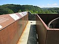
Viewing platform


Web links

Champ Pittet Tower | Chaumont Tower | Donjon de Brigands tower | Gourze Tower | Grangettes Tower | Juergensen Tower | Mont Gibloux transmission tower | Montmagny water tower | Mont Pèlerin television tower | Möösliturm | Round tower | Saint Martin Tower | St. Nicholas Cathedral | Sauvabelin Tower | La Tornallaz