
Tubravić
|
Тубравић Tubravić |
|||||
 The new Serbian Orthodox Church of St. Michael the Archangel in Tubravić |
|||||
|
|||||
| Basic data | |||||
|---|---|---|---|---|---|
| State : | Serbia | ||||
| Okrug : | Kolubara | ||||
| Opština : | Valjevo | ||||
| Coordinates : | 44 ° 12 ' N , 19 ° 44' E | ||||
| Height : | 538 m. i. J. | ||||
| Residents : | 319 (2011) | ||||
| Telephone code : | (+381) 014 | ||||
| License plate : | VA | ||||
| Structure and administration | |||||
| Community type: | Village | ||||


Tubravić ( Serbian Cyrillic : Тубравић) is a village in western Serbia .
geography
The village is located in the Opština Valjevo , in the Okrug Kolubara in the historic Podgorina region in north-western central Serbia .

Tubravić is located on the right bank of the Jablanica River , one of the two headwaters of the Kolubara . In Tubravić there are many springs and headwaters below the individual hills, the springs often bear the names of the families through whose possession they flow.
The river Trubavićska Reka, a tributary of the Sušica, also flows along and through the village . The Trubavićska Reka is created on the locality Sastavci by the confluence of the brooks Vrelo and Sige and other smaller watercourses in the village area and flows into the Jablanica at the hamlet Gračanica.
The village area is very uneven, hilly, karst-rich and steep. On the west side of the village is the large Poćuta basin plain , which is composed of tertiary layers . The eastern and especially the southern part of the village area consists of karst and secondary limestone .
The largest and most important elevations in the village have the following names: Gračanica, Glavica, Drenjak, Document and Brdo . The village houses are on the slopes of the individual hills in the village and in the valleys of the rivers and streams.
The earth of the village is considered to be the most productive of all Podgorina villages. The large fields of the village lie on the right bank of the Jablanica on the former Poćuta lake basin . They are considered the granary not only of Tubravić, but also of the surrounding villages. In spring, the cattle of the inhabitants graze on the large village pastures on Poćuta . The slopes above the village and on the edge of the village are all densely forested.
Tubravić is 90 km southwest of the Serbian capital Belgrade and around 15 km southwest of the municipal capital Valjevo . The village lies on the road that connects Valjevo with the town of Bajina Bašta .
Village hamlet
Tubravić is a typical mountain village and a scattered settlement . The groups of houses are grouped on the slopes of the hills and their indentations. Some of the houses are lined up closely in a circle. The village consists of the following hamlets : Gračanica, Bakići, Tubravić and Sižani . The hamlets are 500 m to one kilometer apart.
- 1.) Gračanica is located on the eastern slope of the hill of the same name, at the confluence of the Sušica in the Jablanica. The following families live in the hamlet: Kovačević and Krdžić. The hamlet is furthest away from the other parts of the village and is difficult to reach from the other hamlets because of the high surrounding hills, which also geographically separate it from the rest of the village.
- 2.) Bakići is located in the southern part of the village on the right bank of the Jablanica below the Brdo hill. The following families live in the hamlet: Jeremić, Marinković, Janković and Stanačić.
- 3.) Tubravić is located south of Bakići on the right bank of Jablanica and the Vrelo brook. The following families live in the hamlet: Đuričić, Lukić, Krstić, Arsić, Gajić, Ignjatović, Milivojević, Marić, Arsenović, Radovanović and Vukosavljević. It is the largest and oldest village hamlet.
- 4.) Sižani is located below the hill and on the left bank of the brook Sige. The following families live in the hamlet: Jovanović, Marković, Živanović, Trifković, Petrović and Nikićević.
population
Tubravić had 319 inhabitants at the 2011 census, compared to 418 inhabitants in 2002. According to the last three population statistics, the number of inhabitants continues to fall, although it increased by 17 people between 1991 and 2002 as a result of the arrival of Serb refugees from Kosovo . The population is made up of Serbs .
Demographics
| year | population |
|---|---|
| 1866 | 413 |
| 1874 | 417 |
| 1884 | 483 |
| 1890 | 506 |
| 1895 | 514 |
| 1900 | 551 |
| 1948 | 880 |
| 1953 | 821 |
| 1961 | 755 |
| 1971 | 678 |
| 1981 | 564 |
| 1991 | 401 |
| 2002 | 418 |
| 2011 | 319 |
history
Tubravić is a very old village. The oldest part of the village Tubrević , where the oldest families from the village still live today, was by the Vrelo brook. Over time, the village grew towards the rivers and the Sige stream. The Đuričić are considered to be the founders of the village. The oldest families in the village include the family mentioned: Lukić, Krstić and Stančić. Other families moved to Tubravić from Herzegovina , Montenegro and Azbukovica in the 17th century .

In 1560, Ottoman records reported about the Serbian Orthodox Gračanica monastery in the village area. Some old graves and the remains of the old Konak monastery testify that the monastery already existed in the 15th century.
In 1818 the village is mentioned in the Ottoman tax records. At that time, Tubravić and today's hamlet Gračanica were listed as two separate places, each with 22 households. At the beginning of the 20th century, the inhabitants of the surrounding towns had also differentiated between Tubravić and Gračanica. The villagers themselves did not perceive the distinction, on the contrary all referred to themselves as residents of Tubravić or the Poćuta plain.
In the hamlet stood the old village church, known as Valjevska Gračanica or Manastir Valjevska Gračanica . This church, consecrated to St. Michael the Archangel , dates from the 19th century (built in 1818) and was flooded in 2016 when the new Rovni jezero reservoir was created . This created a great deal of controversy among the Serbian public. The church was raised again to a monastery a few years before it was flooded .
In the early 20th century the village belonged to the Opština Rebelj in Srez Valjevo.
Infrastructure
The population lives from agriculture, animal husbandry and fruit growing. The village has a primary school, an inn and a village court, which are located on the Markov vouch in the middle of Poćuta.
religion
The population is committed to the Serbian Orthodox Church . In the village on the border with the neighboring village of Brezovice on the locality Bakić Brdo , a new church with the same patronage was built in 2009 near the old flooded church . The new parish church of St. Michael the Archangel , also called Nova Gračanica, with its parsonage, fountain and large churchyard, received the iconostasis and icons of the old church.
gallery

The old lost church (Valjevska Gračanica)

Village road with field and wooded hill
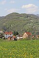
Hill in the foreground houses

Surroundings of Tubravić

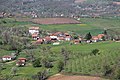
Fields and hamlets
View of groups of houses and the surrounding area
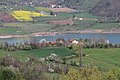
In the background the reservoir Rovni jezero


supporting documents
- Article about the village on the page poreklo.rs , (Serbian)
- Knjiga 9, Stanovništvo, uporedni pregled broja stanovnika 1948, 1953, 1961, 1971, 1981, 1991, 2002, podaci po naseljima, Republički zavod za statistiku, Beograd, maj 2004, ISBN 86-84433-14-9
- Knjiga 1, Stanovništvo, nacionalna ili etnička pripadnost, podaci po naseljima, Republički zavod za statistiku, Beograd, February 2003, ISBN 86-84433-00-9
- Knjiga 2, Stanovništvo, pol i starost, podaci po naseljima, Republički zavod za statistiku, Beograd, February 2003, ISBN 86-84433-01-7