
Valjevo
|
Ваљево Valjevo |
|||||
 Panorama of Valjevo |
|||||
|
|||||
| Basic data | |||||
|---|---|---|---|---|---|
| State : | Serbia | ||||
| Okrug : | Kolubara | ||||
| Coordinates : | 44 ° 16 ' N , 19 ° 53' E | ||||
| Height : | 199 m. i. J. | ||||
| Area : | 22.56 km² | ||||
| Residents : | 59,073 (2011) | ||||
| Agglomeration : | 90,312 (2011) | ||||
| Population density : | 2,618 inhabitants per km² | ||||
| Telephone code : | (+381) 014 | ||||
| Postal code : | 14000 | ||||
| License plate : | VA | ||||
| Structure and administration | |||||
| Community type: | city | ||||
| Mayor : | Zoran Jakovljević ( DS ) | ||||
| Website : | |||||


Valjevo is a city in western Serbia with about 59,000 inhabitants. The city is also the capital of the eponymous municipality in the Kolubara district , which has a total of around 90,000 inhabitants.
geography
Valjevo is located about 100 kilometers southwest of the Serbian capital Belgrade on the northeastern edge of the Dinaric Mountains in a hill country called Podgorina . The three rivers Gradac , Jablanica and Obnica converge in the city and form the Kolubara River from here . Due to the confluence of the rivers, the basin typical of the city has formed. The city center is at a height of around 200 m. i. J.
The areas in the immediate vicinity of the city are predominantly used for agriculture, with the northern slopes of the hills reaching up to a height of 400 meters being usually forested. The mountainous region of the Dinaric Mountains begins about seven kilometers south of the city, and its 1104-meter-high Maljen massif is about 20 kilometers southwest of the city.
The village of Brankovina near Valjevo is known as the home of the Nenadović family. The sights of Brankovina are housed in a cultural and historical complex. The Church of the Holy Archangel, the Archpriest's Castle, Desanka School, the old courtroom, the annex of the Nenadović family, and the graves of the Nenadović family and Desanka Maksimović.
Several old monasteries can be found in the Valjevo area, including Pustinja, Jovanja, Lelić and Ćelije. Not far from Valjevo is the village of Stave which is known for the Church of Saints Peter and Pavle. The sites have been used for religious purposes since the 10th century, with today's church buildings being built between the 14th and 17th centuries. The Pustinja Monastery is located in a remote mountain valley and has rare Serbian medieval frescoes. Excavations have shown that the current church was built on the foundations of a much older church. Parts of the foundation walls and an unidentified grave, much older than the church itself, were discovered. The church is only accessible via a steep path. Despite its inaccessibility, the Turks managed to damage the monastery more than once. It was damaged in 1683 during the Turkish army's campaign towards Vienna. Today Pustinja is an active women's monastery.
history
Valjevo was first mentioned in 1393 as a trading city in the Nemanjid Empire . In 1459 the city was conquered by Ottoman troops. It then remained under the rule of the Ottoman Empire until the 19th century . The associated oriental influence had a decisive influence on urban development at this time. Only with the formation of the Principality of Serbia after the two Serbian uprisings of 1804 and 1815 did a Serbian-influenced development take place again.
In 1855 the city administration decided to build the city according to plan in square quarters that can still be seen in the city center today. The associated modernization led at the end of the 19th century to the construction of a grammar school, the municipal and district court, a savings bank and hotels. At the beginning of the 19th century the city had only about 1000 inhabitants, by the end of the century the number had grown to about 8000.
In the 20th century, Valjevo developed into an important industrial and cultural center in western Serbia, interrupted by the two world wars, during which Valjevo was also badly damaged. In the course of the accelerated industrialization policy of socialist Yugoslavia , the number of inhabitants grew from around 15,000 to around 60,000 between 1948 and 1991, four times as much.
- Picture gallery
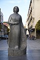
Monument to poet Desanka Maksimović
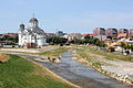
Serbian Orthodox Resurrection Cathedral at the confluence of the Kolubara and Gradac rivers

The city center
Monument to Vuk Stefanović Karadžić

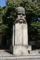
Monument to Field Marshal Živojin Mišić


settlement
In addition to the city, Valjevo extends its administrative area over the following settlements:
|
|
|
economy
The most important employer in the second half of the 20th century was the Krušik arms factory, which returned to production after the wars. In 1999 it was bombed by NATO during the Kosovo war . The rest of Valjevo's economy is characterized by small, private companies in the metallurgy, food production and textile industries. The Austrian company Austrotherm GmbH, the Italian company Golden Lady and the Slovenian company Gorenje have set up production facilities in Valjevo.
Personalities
- Aleksa Nenadović (1749–1804), Prince
- Jakov Nenadović (1765–1836), duke during the first Serbian uprising
- Prota Matija Nenadović (1777-1854), duke during the first Serbian uprising, diplomat
- Ljubomir Nenadović (1826–1895), writer, diplomat, minister
- Milovan Glišić (1847–1908), writer, dramaturge and translator
- Živojin Mišić (1855–1921), field marshal
- Nikolaj Velimirović (1881–1956), Serbian Orthodox bishop
- Desanka Maksimović (1898–1993), poet and literature professor
- Dragoljub Velimirović (1942–2014), chess player
- Slaven Radovanović (* 1947), writer
- Aleksandar Loma (* 1955), scientist
- Miloš Teodosić (* 1987), basketball player
- Matija Nastasić (* 1993), football player