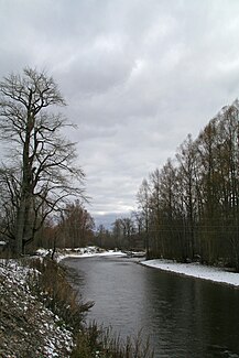
Tym (Sea of Okhotsk)
|
Tym Тымь |
||
| Data | ||
| Water code | RU : 20050000212118300000852 | |
| location | Sakhalin Oblast ( Russia ) | |
| River system | Tym | |
| Headwaters | Southern flank of Lopatin in the Eastern Sakhalin Mountains 50 ° 50 ′ 37 ″ N , 143 ° 9 ′ 7 ″ E |
|
| Source height | approx. 800 m | |
| muzzle | Nyjski Bay ( Sea of Okhotsk ) Coordinates: 51 ° 52 ′ 8 " N , 143 ° 10 ′ 57" E 51 ° 52 ′ 8 " N , 143 ° 10 ′ 57" E |
|
| Mouth height | 0 m | |
| Height difference | approx. 800 m | |
| Bottom slope | approx. 2.4 ‰ | |
| length | 330 km | |
| Catchment area | 7850 km² | |
| Outflow location: 80 km above the mouth |
MQ |
89 m³ / s |
| Left tributaries | Owen, Gromowa, Krasnaja, Malaja Tym , Alexandrowka, Wosji, Nysch , Tschachma | |
| Right tributaries | Belaja, Uskowo, Pilenga , Parkata, Imchin | |
| Small towns | Tymovskoye , Nogliki | |
| Communities | Nysch, Ado-Tymowo, Molodjoschnoje, Woskressenowka | |
|
Catchment area and river course |
||
At 330 km, the Tym ( Russian Тымь ) is the second longest river on the Sakhalin Island in the Far East of Russia . The river name is derived from the Niwchian language and means " spawning river".
River course
The Tym rises on the southern flank of the 1609 m high Lopatin , the highest elevation of Sakhalin, in the Eastern Sakhalin Mountains at an altitude of about 800 m . It initially flows 25 km in a southerly direction through the mountains. Owen and Gromowa flow into the Tym on the left. This then turns 25 km to the west and finally to the north. The Tym flows through the Tym-Poronai lowlands in a northerly direction. The river shows a strongly meandering behavior with countless river bends and oxbow lakes. He passes the small town of Tymovskoye and several localities. Over the last 120 km, the Tym gradually turns north-northeast and finally flows into the Nyjski Bay , a lagoon-like bay on the east coast of Sakhalin, which opens to the Sea of Okhotsk . The small town of Nogliki is located about 15 km above the mouth to the right of the river. Rafting is carried out on the Tym . The lower reaches are navigable for small boats.
The Tym flows through Rajons Tymowski and Noglikski . Notable tributaries are Krasnaya , Malaya Tym , Alexandrowka , Wosji , Nysch and Tschatschma from the left and Belaya , Uskowo , Pilenga , Parkata and Imtschin from the right.
Hydrology
The catchment area of the Tym covers 7850 km². The mean discharge 80 km above the mouth is 89 m³ / s. The river is usually ice-covered from late November to late April. The Tym is fed to a greater extent by the snowmelt . Heavy rain events , such as typically occur with typhoons , can lead to flooding along the course of the river.
Fish fauna
The Tym is a spawning water for various salmon fish .
Web links
- Тымь bei water-rf.ru (НАУЧНО-ПОПУЛЯРНАЯ ЭНЦИКЛОПЕДИЯ; Вода России) (Russian)

